Thynghowe
Thynghowe is an archaeological site in England, United Kingdom. Thynghowe is situated nearby to the coniferous forest Assarts Wood, as well as near the forest Sod Wall Plantation.| Tap on a place to explore it |
Places of Interest Nearby
Highlights include Sherwood Forest and Major Oak.
Sherwood Forest
Nature reserve

Photo: Javier Carro, CC BY-SA 3.0.
Sherwood Forest in Nottinghamshire is the last surviving tract of primeval forest in England. In medieval times it was a royal hunting forest – the shire or sher wood of Nottinghamshire – and it became the setting for the legend of Robin Hood.
Major Oak
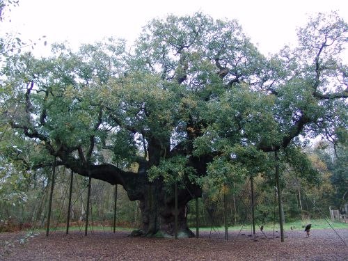
Photo: Galli, Public domain.
The Major Oak is a large English oak near Edwinstowe in the midst of Sherwood Forest, Nottinghamshire, England. According to local folklore, it was Robin Hood's shelter where he and his Merry Men slept. Major Oak is situated 1¼ miles east of Thynghowe.
Warsop Town Hall
Town hall

Photo: Dave Bevis, CC BY-SA 2.0.
Warsop Town Hall is a municipal building in Church Street in Warsop, Nottinghamshire, England. The building is home to Warsop Parish Council, and was formerly the offices of Warsop Urban District Council and the local offices of Nottinghamshire County Council. Warsop Town Hall is situated 2 miles west of Thynghowe.
Places in the Area
Nearby places include Meden Vale and Budby.
Meden Vale
Village

Photo: Dave Bevis, CC BY-SA 2.0.
Meden Vale is a small village near to Church Warsop. The village is part of the parish of Warsop. It is also situated close to the small town of Market Warsop, in north Nottinghamshire, England, off the main A60 Mansfield to Worksop road, and lies within Mansfield District Council administrative area.
Budby
Hamlet

Photo: Alan Heardman, CC BY-SA 2.0.
Budby is a hamlet and former civil parish, now in the parish of Perlethorpe cum Budby, in the Newark and Sherwood district, in the county of Nottinghamshire, England. Budby is situated 1½ miles northeast of Thynghowe.
Edwinstowe

Photo: Andy Stephenson, CC BY-SA 2.0.
Sherwood Forest in Nottinghamshire is the last surviving tract of primeval forest in England. In medieval times it was a royal hunting forest – the shire or sher wood of Nottinghamshire – and it became the setting for the legend of Robin Hood.
Thynghowe
- Type: Archaeological site
- Categories: historic site, tourist attraction, and tourism
- Location: England, United Kingdom, Britain and Ireland, Europe
- View on OpenStreetMap
Latitude
53.20895° or 53° 12′ 32″ northLongitude
-1.10416° or 1° 6′ 15″ westOpen location code
9C5W6V5W+H8OpenStreetMap ID
node 2609585756OpenStreetMap feature
historic=archaeological_site
This page is based on OpenStreetMap, Wikidata, and Wikimedia Commons.
We’d love your help improving our open data sources. Thank you for contributing.
Satellite Map
Discover Thynghowe from above in high-definition satellite imagery.
Notable Places Nearby
Highlights include Assarts Wood and Sod Wall Plantation.
Nearby Places
Explore places such as Sewage Treatment Works and Assarts Farm.
England: Must-Visit Destinations
Delve into London, Manchester, Sheffield, and Leeds.
Curious Archaeological Sites to Discover
Uncover intriguing archaeological sites from every corner of the globe.
About Mapcarta. Data © OpenStreetMap contributors and available under the Open Database License". Text is available under the CC BY-SA 4.0 license, except for photos, directions, and the map. Photo: sidibousaid, CC BY 2.0.