Kennington Lane Kebab
Kennington Lane Kebab is a café in Lambeth, Greater London, England which is located on Kennington Lane. Kennington Lane Kebab is situated nearby to the pub Royal Vauxhall Tavern, as well as near the community center ST. ANNE’S COMMUNITY CENTRE CHILDCARE LTD.| Tap on a place to explore it |
- Type: Café
- Address: 383 Kennington Lane, London, SE11 5QY
- Wheelchair access: no
Places of Interest Nearby
Highlights include Vauxhall Gardens and Vauxhall station.
Vauxhall Gardens
Park
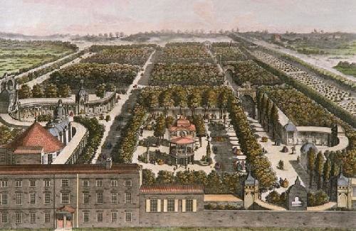
Photo: Samuel Wale, Public domain.
Vauxhall Gardens is a public park in Kennington in the London Borough of Lambeth, England, on the south bank of the River Thames. Originally known as New Spring Gardens, it is believed to have opened before the Restoration of 1660, being mentioned by Samuel Pepys in 1662. Vauxhall Gardens is situated 520 feet north of Kennington Lane Kebab.
Vauxhall station
Railway station
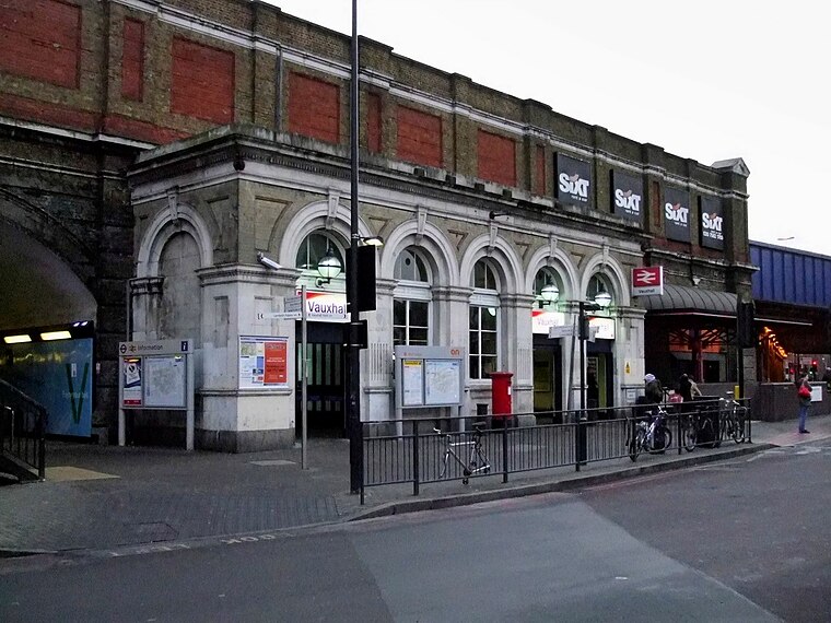
Photo: Sunil060902, CC BY-SA 3.0.
Vauxhall is a National Rail, London Underground and London Buses interchange station in South London. It is at the Vauxhall Cross road junction opposite the southern approach to Vauxhall Bridge over the River Thames in the district of Vauxhall. Vauxhall station is situated 390 feet west of Kennington Lane Kebab.
The Oval
Stadium

Photo: Jguk, Public domain.
The Oval, currently named for sponsorship reasons as the Kia Oval, is an international cricket ground in Kennington, located in the borough of Lambeth, in south London. The Oval is situated 1,600 feet southeast of Kennington Lane Kebab.
Places in the Area
Nearby places include Vauxhall and St George Wharf.
Vauxhall
Suburb
Photo: Wikimedia, CC BY-SA 3.0.
Vauxhall is an area of South London, within the London Borough of Lambeth. Named after a medieval manor called Fox Hall, it became well known for the Vauxhall Pleasure Gardens.
St George Wharf
Neighborhood

Photo: Jamesbeard, CC BY-SA 4.0.
St George Wharf is a riverside development in Vauxhall, Lambeth, London, England, located on the southern bank of the River Thames beside Vauxhall Bridge.
Kennington Cross
Neighborhood

Photo: Jwslubbock, CC BY-SA 4.0.
Kennington Cross is a locality in the London Borough of Lambeth. It is at the junction of two major roads, Kennington Lane that links Vauxhall Cross with the Elephant and Castle and Kennington Road that runs from Waterloo to Kennington Park.
Kennington Lane Kebab
Latitude
51.48607° or 51° 29′ 10″ northLongitude
-0.12107° or 0° 7′ 16″ westOpen location code
9C3XFVPH+CHOpenStreetMap ID
node 2664132506OpenStreetMap feature
amenity=cafeOpenStreetMap attribute
wheelchair=no
This page is based on OpenStreetMap, Wikidata, and Wikimedia Commons.
We’d love your help improving our open data sources. Thank you for contributing.
Satellite Map
Discover Kennington Lane Kebab from above in high-definition satellite imagery.
Notable Places Nearby
Highlights include Royal Vauxhall Tavern and ST. ANNE’S COMMUNITY CENTRE CHILDCARE LTD.
Nearby Places
Explore places such as Dexters and KFC.
London: Must-Visit Destinations
Delve into South Kensington-Chelsea, Heathrow Airport, City of London, and Westminster.
Curious Cafés to Discover
Uncover intriguing cafés from every corner of the globe.
About Mapcarta. Data © OpenStreetMap contributors and available under the Open Database License". Text is available under the CC BY-SA 4.0 license, except for photos, directions, and the map. Photo: brodiepunk, CC BY 2.0.