BP
BP is a gas station in England, United Kingdom. BP is situated nearby to West End Park, as well as near Ashton under Lyne Police Station.| Tap on a place to explore it |
Places of Interest Nearby
Highlights include St Peter’s Church, Ashton-under-Lyne and Tameside Hippodrome.
St Peter’s Church, Ashton-under-Lyne
Church

Photo: Wikimedia, CC BY-SA 2.0.
St Peter's Church is in Manchester Road, Ashton-under-Lyne, Greater Manchester, England. It is an active Anglican parish church in the deanery of Ashton-under-Lyne, the archdeaconry of Rochdale, and the diocese of Manchester. St Peter’s Church, Ashton-under-Lyne is situated 680 feet east of BP.
Tameside Hippodrome
Theater building

Photo: Gerald England, CC BY-SA 2.0.
Tameside Hippodrome is a 1262 seat theatre located in Ashton-under-Lyne, Greater Manchester, England. Tameside Hippodrome is situated 3,000 feet northeast of BP.
Guide Bridge railway station
Railway station

Photo: Whohe!, CC BY-SA 3.0.
Guide Bridge railway station serves Guide Bridge, Greater Manchester, England, and is operated by Northern Trains. The station is 4+3⁄4 miles east of Manchester Piccadilly on both the Rose Hill Marple and Glossop Lines. Guide Bridge railway station is situated 3,300 feet south of BP.
Places in the Area
Nearby places include Ashton-under-Lyne and Dukinfield.
Ashton-under-Lyne
Town
 Ashton-under-Lyne is a market town in Tameside, Greater Manchester, England. The population was 48,604 at the 2021 census. Historically in Lancashire, it is on the north bank of the River Tame, in the foothills of the Pennines, six miles east of Manchester.
Dukinfield
Town
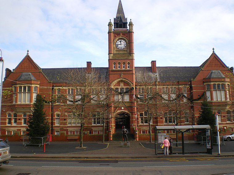
Photo: Wikimedia, CC BY-SA 2.0.
Dukinfield is a town in Tameside, Greater Manchester, England, on the south bank of the River Tame opposite Ashton-under-Lyne, 6.3 miles east of Manchester.
Guide Bridge
Suburb
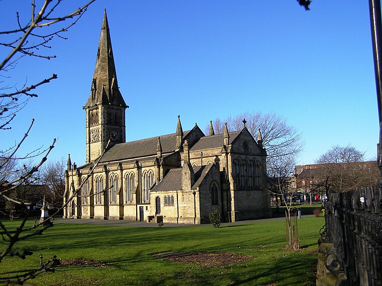
Photo: David Dixon, CC BY-SA 2.0.
Guide Bridge is an area west of Ashton-under-Lyne in Greater Manchester, England. Historically part of Lancashire, Guide Bridge was built as a village around an eponymous bridge over the Ashton Canal.
BP
- Type: Gas station
- Category: transportation
- Location: England, United Kingdom, Britain and Ireland, Europe
- View on OpenStreetMap
Latitude
53.48327° or 53° 28′ 60″ northLongitude
-2.10879° or 2° 6′ 32″ westBrand
BPOperator
Motor Fuel GroupOpen location code
9C5VFVMR+8FOpenStreetMap ID
node 269256564OpenStreetMap feature
amenity=fuel
This page is based on OpenStreetMap, Wikidata, and Wikimedia Commons.
We’d love your help improving our open data sources. Thank you for contributing.
Satellite Map
Discover BP from above in high-definition satellite imagery.
Notable Places Nearby
Highlights include West End Park and Ashton under Lyne Police Station.
Nearby Places
Explore places such as Londis and Subway.
England: Must-Visit Destinations
Delve into London, Manchester, Sheffield, and Leeds.
Curious Gas Stations to Discover
Uncover intriguing gas stations from every corner of the globe.
About Mapcarta. Data © OpenStreetMap contributors and available under the Open Database License". Text is available under the CC BY-SA 4.0 license, except for photos, directions, and the map. Photo: sidibousaid, CC BY 2.0.