Sítio da Assumada
Sítio da Assumada is a chalet in Fajã Grande, Lajes das Flores Municipality which is located on Estrada Regional da Fajã Grande. Sítio da Assumada is situated nearby to the scenic viewpoint Vigia da Baleia, as well as near the church Capela de Santo António de Lisboa.| Tap on a place to explore it |
- Email: sitiodaassumada@hotmail.com
- Type: Chalet
- Address: Estrada Regional da Fajã Grande, Fajã Grande, 9960-010
- Wheelchair access: yes
Places of Interest Nearby
Highlights include Lagoa Branca and Lagoa Comprida.
Lagoa Branca
Lake

Photo: Gagofoto, CC BY-SA 4.0.
Lagoa Branca is a lake, which is situated 3 km east of Sítio da Assumada.
Lagoa Comprida
Lake
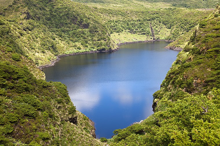
Photo: Unukorno, CC BY-SA 3.0.
Lagoa Comprida is a lake, which is situated 3½ km east of Sítio da Assumada.
Morro Alto
Peak

Photo: Luissilveira, Public domain.
Morro Alto is the highest mountain of Flores, Azores, Portugal. It is part of a trachytic process represented by the Pico da Sé, forming an imposing volcanic apparatus embedded between two deep erosion valleys, product of the Badanela and Fazenda rivers. Morro Alto is situated 4 km northeast of Sítio da Assumada.
Places in the Area
Nearby places include Fajã de Lopo Vaz.
Fajã de Lopo Vaz
Hamlet

Photo: Dreizung, Public domain.
The Fajã de Lopo Vaz is a permanent debris field, built from the collapsing cliffs on the southern coast of the civil parish of Lajes, municipality of the same name, island of Flores, in the Portuguese archipelago of the Azores. Fajã de Lopo Vaz is situated 9 km southeast of Sítio da Assumada.
Sítio da Assumada
- Categories: tourism, accommodation, and building
- Location: Fajã Grande, Lajes das Flores Municipality, Azores, Portugal, Iberia, Europe
- View on OpenStreetMap
Latitude
39.4481° or 39° 26′ 53″ northLongitude
-31.26032° or 31° 15′ 37″ westOpen location code
89FCCPXQ+6VOpenStreetMap ID
node 2807690601OpenStreetMap feature
tourism=chaletOpenStreetMap attribute
wheelchair=yes
This page is based on OpenStreetMap, Wikidata, and Wikimedia Commons.
We’d love your help improving our open data sources. Thank you for contributing.
Satellite Map
Discover Sítio da Assumada from above in high-definition satellite imagery.
Notable Places Nearby
Highlights include Vigia da Baleia and Capela de Santo António de Lisboa.
Nearby Places
Explore places such as Flores Dive Center and Casa do Zé da Laura.
Azores: Must-Visit Destinations
Delve into Terceira, Ponta Delgada, Angra do Heroísmo, and Pico.
Curious Chalets to Discover
Uncover intriguing chalets from every corner of the globe.
About Mapcarta. Data © OpenStreetMap contributors and available under the Open Database License". Text is available under the CC BY-SA 4.0 license, except for photos, directions, and the map. Photo: Tsy1980, CC BY-SA 4.0.