SANEYE B
SANEYE B is a school in Gao, Mali. SANEYE B is situated nearby to the government office Direction Régionale de la protection de la Femme et de la Fille de Gao, as well as near the pitch soccer.| Tap on a place to explore it |
Places of Interest Nearby
Highlights include Tomb of Askia Unesco world heritage site.
Tomb of Askia Unesco world heritage site
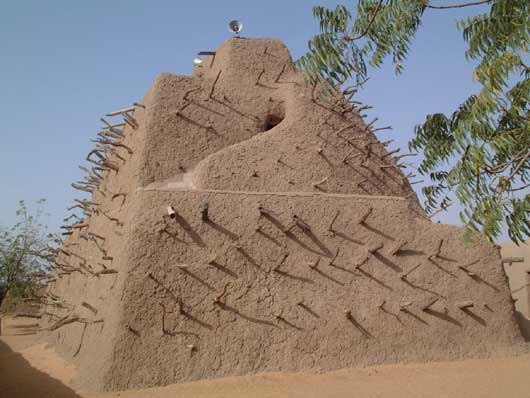
Photo: Taguelmoust, CC BY-SA 3.0.
The Tomb of Askia, in Gao, Mali, is believed to be the burial place of Askia Muhammad I, one of the Songhai Empire's most prolific emperors. It was built at the end of the fifteenth century and is designated as a UNESCO World Heritage Site. Tomb of Askia Unesco world heritage site is situated 2 km north of SANEYE B.
Places in the Area
Nearby places include Gao and Wabaria.
Gao

Photo: David Sessoms, CC BY-SA 2.0.
Gao is a city in Mali and the capital of the Gao Region. The city is located on the River Niger, 320 km east-southeast of Timbuktu on the left bank at the junction with the Tilemsi valley.
Wabaria
Town
Wabaria is a small town and seat of the Commune of Gounzoureye in the Cercle of Gao in the Gao Region of south-eastern Mali. Wabaria is situated 9 km south of SANEYE B.
SANEYE B
Latitude
16.26997° or 16° 16′ 12″ northLongitude
-0.04702° or 0° 2′ 49″ westOpen location code
7C8X7X93+X5OpenStreetMap ID
node 3079741310OpenStreetMap feature
amenity=school
This page is based on OpenStreetMap, Wikidata, and Wikimedia Commons.
We’d love your help improving our open data sources. Thank you for contributing.
Satellite Map
Discover SANEYE B from above in high-definition satellite imagery.
Notable Places Nearby
Highlights include Direction Régionale de la protection de la Femme et de la Fille de Gao and soccer.
Nearby Places
Explore places such as SANEYE A and SOMAGEP.
Curious Schools to Discover
Uncover intriguing schools from every corner of the globe.
About Mapcarta. Data © OpenStreetMap contributors and available under the Open Database License". Text is available under the CC BY-SA 4.0 license, except for photos, directions, and the map. Photo: Wikimedia, CC0.