Garola House Crossing
Garola House Crossing is a level crossing in South Killingholme, North Lincolnshire, England. Garola House Crossing is situated nearby to the forest Sinks Covert, as well as near the hamlet Ulceby Skitter.| Tap on a place to explore it |
Places of Interest Nearby
Highlights include Ulceby railway station and Thornton Abbey railway station.
Ulceby railway station
Railway station

Photo: David Wright, CC BY-SA 2.0.
Ulceby railway station serves the village of Ulceby in North East Lincolnshire, England. It was built by the Great Grimsby and Sheffield Junction Railway in 1848 and is located at Ulceby Skitter. Ulceby railway station is situated 1 mile south of Garola House Crossing.
Thornton Abbey railway station
Railway station

Photo: David Wright, CC BY-SA 2.0.
Thornton Abbey railway station is close to the site of Thornton Abbey in North Lincolnshire, England. It was built by the Great Grimsby and Sheffield Junction Railway in 1849, replacing a temporary one at Thornton Curtis. Thornton Abbey railway station is situated 1½ miles north of Garola House Crossing.
Thornton Abbey Gatehouse
City gate
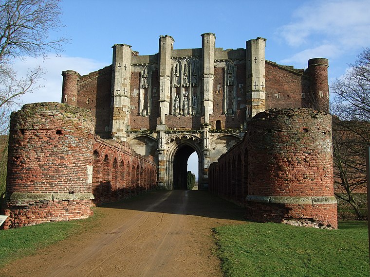
Photo: David Wright, CC BY 2.0.
Thornton Abbey Gatehouse is a city gate, which is situated 1½ miles north of Garola House Crossing.
Places in the Area
Nearby places include Ulceby Skitter and Ulceby.
Ulceby Skitter
Hamlet

Photo: David Wright, CC BY-SA 2.0.
Ulceby Skitter is a hamlet in North Lincolnshire, England. It is situated less than 1 mile north-west from the Brocklesby Interchange of the A180 road, and 3 miles west from Immingham.
Ulceby
Village
 Ulceby is a village and civil parish in North Lincolnshire, England. It is situated 0.5 miles north from the A180 road, 10 miles north-west from Grimsby and 14 miles east from Scunthorpe.
North Killingholme
Village

Photo: David Wright, CC BY-SA 2.0.
North Killingholme is a small village and civil parish in North Lincolnshire, England. Situated on the southern bank of the Humber Estuary north-west of Grimsby, Killingholme is divided into two administrative districts, to its south being the civil parish of South Killingholme. North Killingholme is situated 1½ miles east of Garola House Crossing.
Garola House Crossing
- Type: Level crossing
- Category: transportation
- Location: South Killingholme, North Lincolnshire, England, United Kingdom, Britain and Ireland, Europe
- View on OpenStreetMap
Latitude
53.63365° or 53° 38′ 1″ northLongitude
-0.30992° or 0° 18′ 36″ westOpen location code
9C5XJMMR+F2OpenStreetMap ID
node 3139247420OpenStreetMap feature
railway=crossing
This page is based on OpenStreetMap, Wikidata, and Wikimedia Commons.
We’d love your help improving our open data sources. Thank you for contributing.
Satellite Map
Discover Garola House Crossing from above in high-definition satellite imagery.
Notable Places Nearby
Highlights include Sinks Covert and South Cloister Covert.
Nearby Places
Explore places such as Garola House Crossing and Meadow Croft Farm.
England: Must-Visit Destinations
Delve into London, Manchester, Sheffield, and Leeds.
Curious Level Crossings to Discover
Uncover intriguing level crossings from every corner of the globe.
About Mapcarta. Data © OpenStreetMap contributors and available under the Open Database License". Text is available under the CC BY-SA 4.0 license, except for photos, directions, and the map. Photo: sidibousaid, CC BY 2.0.