Puertas de Fierro
Puertas de Fierro is a neighborhood in Rancagua, Cachapoal Province, O’Higgins Region. Puertas de Fierro is situated nearby to the neighborhood Los Mantos, as well as near Flor de Las Nieves.| Tap on a place to explore it |
Places of Interest
Highlights include Rancagua de la Independencia Airport and Rancagua Regional Hospital.
Rancagua de la Independencia Airport
Aerodrome
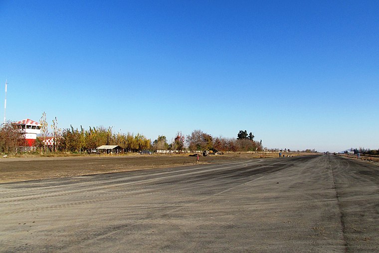
Photo: Marco Antonio Correa Flores, CC BY-SA 4.0.
De la Independencia Aerodrome is an airport serving Rancagua, a city in the O'Higgins Region of Chile. The airport is on the west side of the city. There is distant mountainous terrain east and west of the runway.
Rancagua Regional Hospital
Hospital
Photo: Warko, CC BY-SA 4.0.
Rancagua Regional Hospital is situated 2½ km northeast of Puertas de Fierro.
Rancagua railway station
Railway station

Photo: Carlos yo, CC BY-SA 4.0.
Estación Rancagua is a railway station of the Empresa de los Ferrocarriles del Estado in Rancagua, Chile. It is the main railway station in the Libertador General Bernardo O'Higgins Region. Rancagua railway station is situated 2½ km east of Puertas de Fierro.
Places in the Area
Nearby places include Olivar and Los Lirios.
Olivar
Village

Photo: Wikimedia, CC BY-SA 3.0.
Olivar is a commune in Chile, located in the O'Higgins Region, 10 km south of Rancagua, and administered by the municipality of Olivar. The main economic activities range from agriculture and food production, especially apples for exportation. Olivar is situated 5 km southwest of Puertas de Fierro.
Los Lirios
Village

Photo: Aeveraal, CC BY-SA 3.0.
Los Lirios is a village, which is situated 6 km south of Puertas de Fierro.
Chancón
Hamlet

Photo: R.A.T.P., CC BY-SA 3.0.
Chancón is a hamlet, which is situated 9 km north of Puertas de Fierro.
Puertas de Fierro
- Type: Neighborhood
- Category: locality
- Location: Rancagua, Cachapoal Province, O’Higgins Region, Central Chile, Chile, South America
- View on OpenStreetMap
Latitude
-34.1753° or 34° 10′ 31″ southLongitude
-70.78107° or 70° 46′ 52″ westOpen location code
47QFR6F9+VHOpenStreetMap ID
node 3323241843OpenStreetMap feature
place=neighbourhood
This page is based on OpenStreetMap, Wikidata, and Wikimedia Commons.
We’d love your help improving our open data sources. Thank you for contributing.
Satellite Map
Discover Puertas de Fierro from above in high-definition satellite imagery.
Places with the Same Name
Discover other places named “Puertas de Fierro”.
Localities in the Area
Explore places such as Los Mantos and Flor de Las Nieves.
Notable Places Nearby
Highlights include Plaza Activa and Terminal Línea Microbuses Cachapoal.
Central Chile: Must-Visit Destinations
Delve into Santiago, Valparaíso, Pichilemu, and Viña del Mar.
Curious Neighborhoods to Discover
Uncover intriguing neighborhoods from every corner of the globe.
About Mapcarta. Data © OpenStreetMap contributors and available under the Open Database License". Text is available under the CC BY-SA 4.0 license, except for photos, directions, and the map. Photo: Marco Antonio Correa Flores, CC BY-SA 4.0.