Baltyboys Lower
Baltyboys Lower is a locality in County Wicklow, Leinster. Baltyboys Lower is situated nearby to the locality Burgage Moyle, as well as near Russellstown.| Tap on a place to explore it |
Places of Interest
Highlights include Baltyboys House and St. Mark’s Cross.
Baltyboys House
Building
Baltyboys House, also known as Boystown House, is an 18th-century Georgian country house close to Blessington, County Wicklow, Ireland. Baltyboys House is a mansion built in the Georgian style.
St. Mark’s Cross
Cross

Photo: 瑞丽江的河水, CC BY-SA 4.0.
St. Mark's Cross is a high cross and National Monument located in Blessington, County Wicklow, Ireland. St. Mark’s Cross is situated 2½ km north of Baltyboys Lower.
St Mary’s Church
Church

Photo: 瑞丽江的河水, CC BY-SA 4.0.
St. Mary's Church is a Church of Ireland church located in Blessington, County Wicklow, Ireland. The church was built by Michael Boyle, Archbishop of Armagh in the 1670s and 1680s, and dedicated on 17 September 1683. St Mary’s Church is situated 3½ km north of Baltyboys Lower.
Places in the Area
Nearby places include Lacken and Valleymount.
Lacken
Hamlet
Lacken or Lackan is a townland and small village in the west of County Wicklow, Ireland, located on the shores of the Blessington lakes and western edge of the Wicklow Mountains. Lacken is situated 3 km east of Baltyboys Lower.
Valleymount
Village
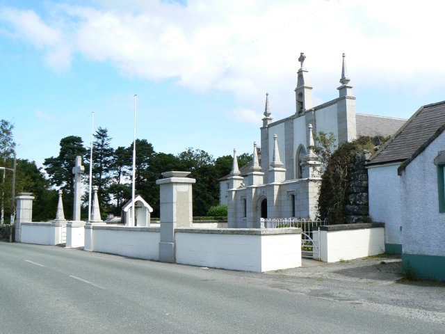
Photo: James Allan, CC BY-SA 2.0.
Valleymount is a small village in western County Wicklow, Ireland. The name 'Valleymount' does not appear before 1839. Previously, the village was known as 'the Cross of Ballymore' or simply 'the Cross', with 'cross' referring to land belonging to the church. Valleymount is situated 3½ km south of Baltyboys Lower.
Blessington

Photo: 瑞丽江的河水, CC BY-SA 4.0.
Blessington is a small town in County Wicklow, with a population in 2022 of about 5600. It's west of the Wicklow mountains and this part of the county is low-lying and rural.
Baltyboys Lower
- Type: Locality
- Also known as: “Boystown”
- Location: County Wicklow, Leinster, East Coast and Midlands, Ireland, Britain and Ireland, Europe
- View on OpenStreetMap
Latitude
53.13945° or 53° 8′ 22″ northLongitude
-6.52953° or 6° 31′ 46″ westOpen location code
9C5M4FQC+Q5OpenStreetMap ID
node 3338261800OpenStreetMap feature
place=locality
This page is based on OpenStreetMap, Wikidata, and Wikimedia Commons.
We’d love your help improving our open data sources. Thank you for contributing.
Satellite Map
Discover Baltyboys Lower from above in high-definition satellite imagery.
Places with the Same Name
Discover other places named “Baltyboys Lower”.
Localities in the Area
Explore places such as Burgage Moyle and Russellstown.
Notable Places Nearby
Highlights include Blessington Sailing Club and Baltyboys Cemetery.
County Wicklow: Must-Visit Destinations
Delve into Bray, Wicklow Town, Arklow, and Glendalough.
Curious Localities to Discover
Uncover intriguing localities from every corner of the globe.
About Mapcarta. Data © OpenStreetMap contributors and available under the Open Database License". Text is available under the CC BY-SA 4.0 license, except for photos, directions, and the map. Photo: Wikimedia, CC BY-SA 3.0.