Station Apeldoorn
Station Apeldoorn is a bus station in Apeldoorn Municipality, Gelderland. Station Apeldoorn is situated nearby to the government office Belastingdienst, as well as near Apeldoorn railway station.| Tap on a place to explore it |
Places of Interest Nearby
Highlights include Apeldoorn railway station and Travelling Sand.
Apeldoorn railway station
Railway station
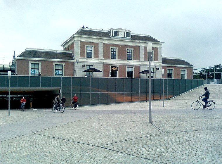 Apeldoorn railway station is a railway station in Apeldoorn, Netherlands. The station was opened on 15 May 1876, on the Amsterdam–Zutphen railway. It was opened when the Amersfoort to Zutphen section was completed.
Travelling Sand
Work of art

Photo: Erik Wannee, CC BY-SA 3.0.
Travelling Sand is a work of art, which is situated 100 metres west of Station Apeldoorn.
Onze Lieve Vrouwe ten Hemelopnemingkerk
Church

Photo: Kleinleugenmors, CC BY-SA 3.0 nl.
Onze Lieve Vrouwe ten Hemelopnemingkerk is a church, which is situated 250 metres northwest of Station Apeldoorn.
Places in the Area
Nearby places include Apeldoorn and Ugchelen.
Apeldoorn

Photo: Kleinleugenmors, CC BY-SA 3.0.
Apeldoorn is a city with a royal touch, famous for its palace and beautiful gardens. It lies on the edge of National Park the Veluwe, and is an excellent base to explore this region's lush natural surroundings.
Ugchelen
Village
Ugchelen is part of the municipality of Apeldoorn in the Gelderland province of the Netherlands, and is today seen as a village. Ugchelen is located South West of Apeldoorn and has about 7000 inhabitants. Ugchelen is situated 3½ km southwest of Station Apeldoorn.
Wenum
Village
Wenum-Wiesel is a twin village in the municipality of Apeldoorn, in the province of Gelderland in the Netherlands. In 1978, the hamlets of Wenum and Wiesel merged into a village. Wenum is situated 5 km north of Station Apeldoorn.
Station Apeldoorn
- Type: Bus station
- Wheelchair access: yes
- Categories: station and transportation
- Location: Apeldoorn Municipality, Gelderland, Eastern Netherlands, Netherlands, Benelux, Europe
- View on OpenStreetMap
Latitude
52.20975° or 52° 12′ 35″ northLongitude
5.9702° or 5° 58′ 13″ eastOpen location code
9F476X5C+V3OpenStreetMap ID
node 3415908532OpenStreetMap feature
amenity=bus_stationOpenStreetMap feature
public_transport=stationOpenStreetMap attribute
wheelchair=yes
This page is based on OpenStreetMap, Wikidata, and Wikimedia Commons.
We’d love your help improving our open data sources. Thank you for contributing.
Satellite Map
Discover Station Apeldoorn from above in high-definition satellite imagery.
Places with the Same Name
Discover other places named “Station Apeldoorn”.
Notable Places Nearby
Highlights include Belastingdienst and Apeldoorn.
Nearby Places
Explore places such as Apeldoorn, Station and Station.
Gelderland: Must-Visit Destinations
Delve into Arnhem, Nijmegen, Ede, and Zutphen.
Curious Bus Stations to Discover
Uncover intriguing bus stations from every corner of the globe.
About Mapcarta. Data © OpenStreetMap contributors and available under the Open Database License". Text is available under the CC BY-SA 4.0 license, except for photos, directions, and the map. Photo: Agnes Monkelbaan, CC BY-SA 4.0.