My Garden Cafe
My Garden Cafe is a café in Stanislaus County, San Joaquin Valley, California. My Garden Cafe is situated nearby to the hospital Modern Urgent Care, as well as near the pitch JV Baseball Field.| Tap on a place to explore it |
Places of Interest Nearby
Highlights include Modesto City-County Airport and Central Valley High School.
Modesto City-County Airport
Aerodrome
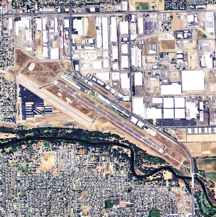
Photo: USGS, Public domain.
Modesto City–County Airport is two miles southeast of Modesto in Stanislaus County, California, United States. Modesto City-County Airport is situated 2 miles north of My Garden Cafe.
Central Valley High School
School
Central Valley High School is an American public high school for students between the 9th and 12th grade. It is a large school, with over 2,200 students. Central Valley High School is situated 1¼ miles southwest of My Garden Cafe.
Places in the Area
Nearby places include Ceres and Bystrom.
Ceres

Photo: Ryanx7, CC BY-SA 4.0.
Ceres is a city in Stanislaus County located in the agriculturally abundant San Joaquin Valley of California.
Bystrom
Neighborhood
Bystrom is a census-designated place in Stanislaus County, California, United States. The population was 3,957 at the 2020 census, down from 4,008 at the 2010 census. It is part of the Modesto Metropolitan Statistical Area. Bystrom is situated 2½ miles northwest of My Garden Cafe.
Shackelford
Neighborhood
Shackelford is a southern neighbourhood of the city of Modesto in Stanislaus County, California, United States, which was officially annexed on June 1, 2012. Shackelford is situated 2½ miles northwest of My Garden Cafe.
My Garden Cafe
- Type: Café
- Location: Stanislaus County, San Joaquin Valley, California, United States, North America
- View on OpenStreetMap
Latitude
37.59529° or 37° 35′ 43″ northLongitude
-120.94841° or 120° 56′ 54″ westOpen location code
849XH3W2+4JOpenStreetMap ID
node 3466889400OpenStreetMap feature
amenity=cafe
This page is based on OpenStreetMap, Wikidata, and Wikimedia Commons.
We’d love your help improving our open data sources. Thank you for contributing.
Satellite Map
Discover My Garden Cafe from above in high-definition satellite imagery.
Places with the Same Name
Discover other places named “My Garden Cafe”.
Notable Places Nearby
Highlights include Modern Urgent Care and JV Baseball Field.
Nearby Places
Explore places such as ampm and BMO Banking Center.
Stanislaus County: Must-Visit Destinations
Delve into Modesto, Turlock, Oakdale, and Patterson.
Curious Cafés to Discover
Uncover intriguing cafés from every corner of the globe.
About Mapcarta. Data © OpenStreetMap contributors and available under the Open Database License". Text is available under the CC BY-SA 4.0 license, except for photos, directions, and the map. Photo: Wikimedia, CC0.