Lythe Farmhouse
Lythe Farmhouse is a farm in Stroud, East Hampshire, England. Lythe Farmhouse is situated nearby to the forest Home Copse, as well as near Lythe Copse.| Tap on a place to explore it |
- Type: Farm
- Description: farmhouse in Steep, East Hampshire, England, UK
- Also known as: “Lythe Farm”
Places of Interest Nearby
Highlights include Petersfield railway station and Bedales School.
Petersfield railway station
Railway station
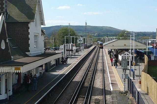
Photo: Graham Horn, CC BY-SA 2.0.
Petersfield railway station serves the market town of Petersfield, Hampshire, England. It is on the Portsmouth Direct line, 54 miles 71 chains down the line from London Waterloo via Woking. Petersfield railway station is situated 1½ miles southeast of Lythe Farmhouse.
Bedales School
School

Photo: Martyn Pattison, CC BY-SA 2.0.
Bedales School is a coeducational boarding and day public school, in the village of Steep, near the market town of Petersfield in Hampshire, England. It was founded in 1893 by Amy Garrett Badley and John Haden Badley in reaction to the limitations of conventional Victorian schools and has been co-educational since 1898. Bedales School is situated 1¼ miles east of Lythe Farmhouse.
Petersfield Hospital
Hospital

Photo: Martyn Pattison, CC BY-SA 2.0.
Petersfield Hospital is a health facility in Swan Street, Petersfield, Hampshire, England. It is managed by Southern Health NHS Foundation Trust. Petersfield Hospital is situated 1½ miles southeast of Lythe Farmhouse.
Places in the Area
Nearby places include Froxfield Green and High Cross.
Froxfield Green
Hamlet

Photo: Trish Steel, CC BY-SA 2.0.
Froxfield Green is a village in the civil parish of Froxfield and Privett, in the East Hampshire district of Hampshire, England. It is 3 miles north-west of Petersfield, and lies just north of the A272 road.
High Cross
Village

Photo: Michael FORD, CC BY-SA 2.0.
High Cross is a village in the East Hampshire district of Hampshire, England. It lies in Froxfield and Privett parish, about 3 miles north-west of Petersfield, north of the A272 road.
Petersfield

Photo: Bashereyre, CC BY-SA 3.0.
Petersfield is a market town and civil parish in the East Hampshire district of Hampshire, England. It is 15 miles north of Portsmouth. The town has its own railway station on the Portsmouth Direct line, the mainline rail link connecting Portsmouth and London.
Lythe Farmhouse
- Categories: farmhouse, locality, and agriculture
- Location: Stroud, East Hampshire, Hampshire, South East England, England, United Kingdom, Britain and Ireland, Europe
- View on OpenStreetMap
Latitude
51.01711° or 51° 1′ 2″ northLongitude
-0.96891° or 0° 58′ 8″ westOpen location code
9C3X228J+RCOpenStreetMap ID
node 3468418072OpenStreetMap feature
place=farmWikidata ID
Q26386750
This page is based on OpenStreetMap, Wikidata, and Wikimedia Commons.
We’d love your help improving our open data sources. Thank you for contributing.
Satellite Map
Discover Lythe Farmhouse from above in high-definition satellite imagery.
Notable Places Nearby
Highlights include Home Copse and Lythe Copse.
Nearby Places
Explore places such as Broadmeadow Farm and Aldersnapp Farm.
Hampshire: Must-Visit Destinations
Delve into Southampton, Portsmouth, Winchester, and Farnborough.
Curious Farms to Discover
Uncover intriguing farms from every corner of the globe.
About Mapcarta. Data © OpenStreetMap contributors and available under the Open Database License". Text is available under the CC BY-SA 4.0 license, except for photos, directions, and the map. Photo: TomHab, CC BY-SA 3.0.