Wasserwerk Mombach
Wasserwerk Mombach is a reservoir in Mainz, Rhenish Hesse, Rhineland-Palatinate. Wasserwerk Mombach is situated nearby to the locality Die sechs Morgen, as well as near Der Sandbruch.| Tap on a place to explore it |
Places of Interest
Highlights include Biebrich Palace and Bruchwegstadion.
Biebrich Palace

Photo: SBT, CC BY-SA 4.0.
Biebrich Palace is a Baroque residence in the borough of Biebrich in the city of Wiesbaden, Hesse, Germany. Built in 1702 by Prince Georg August Samuel of Nassau-Idstein, it served as the ducal residence for the independent Duchy of Nassau from 1816 until 1866.
Bruchwegstadion
Stadium

Photo: Jorgenpfhartogs, Public domain.
The Bruchwegstadion is a multi-purpose stadium in Mainz, Germany. It is currently used mostly for football matches. The stadium is able to hold 18,700 people and was built in 1929.
Rettbergsaue
Island

Photo: Martin Kraft, CC BY-SA 3.0.
The Rettbergsaue is a natural island in the Rhine River at Wiesbaden, Germany. It is situated between the main channel of the Rhine to the north and a smaller channel, the Wachsbleicharm, in the south.
Places in the Area
Nearby places include Biebrich and Hartenberg-Münchfeld.
Biebrich
Suburb
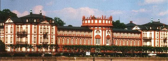
Photo: Wikimedia, Public domain.
Biebrich is a borough of the city of Wiesbaden, Hesse, Germany. With over 38,000 inhabitants, it is the most-populated of Wiesbaden's boroughs. It is located south of the city center on the Rhine River, opposite the Mainz borough of Mombach.
Hartenberg-Münchfeld
Suburb
Hartenberg-Münchfeld is a borough of the Rhineland-Palatinate state capital Mainz, Germany. Hartenberg-Münchfeld is known for the Bruchwegstadion former home of first league football club of 1.
Budenheim
Village
Budenheim is a municipality in the Mainz-Bingen district in Rhineland-Palatinate, Germany. Unlike other municipalities in Mainz-Bingen, it does not belong to any association of municipalities.
Wasserwerk Mombach
- Type: Reservoir
- Categories: historic site and body of water
- Location: Mainz, Rhenish Hesse, Rhineland-Palatinate, Germany, Central Europe, Europe
- View on OpenStreetMap
Latitude
50.0172° or 50° 1′ 2″ northLongitude
8.2201° or 8° 13′ 12″ eastOpen location code
9F2C268C+V2OpenStreetMap ID
node 3468957431OpenStreetMap feature
historic=yesOpenStreetMap feature
man_made=reservoir_covered
This page is based on OpenStreetMap, Wikidata, and Wikimedia Commons.
We’d love your help improving our open data sources. Thank you for contributing.
Satellite Map
Discover Wasserwerk Mombach from above in high-definition satellite imagery.
Localities in the Area
Explore places such as Mombach and Die sechs Morgen.
Notable Places Nearby
Highlights include De-La-Roche-Anlage and Am Roten Berg.
Rhenish Hesse: Must-Visit Destinations
Delve into Worms, Bingen, Ingelheim, and Oppenheim.
Curious Reservoirs to Discover
Uncover intriguing reservoirs from every corner of the globe.
About Mapcarta. Data © OpenStreetMap contributors and available under the Open Database License". Text is available under the CC BY-SA 4.0 license, except for photos, directions, and the map. Photo: Traveler100, CC BY-SA 4.0.