Cimla Hill
Cimla Hill is a peak in Neath, Wales and has an elevation of 561 feet. Cimla Hill is situated nearby to the village Efail-fach, as well as near Pontrhydyfen.| Tap on a place to explore it |
Places of Interest
Highlights include Neath railway station and Neath Castle.
Neath railway station
Railway station
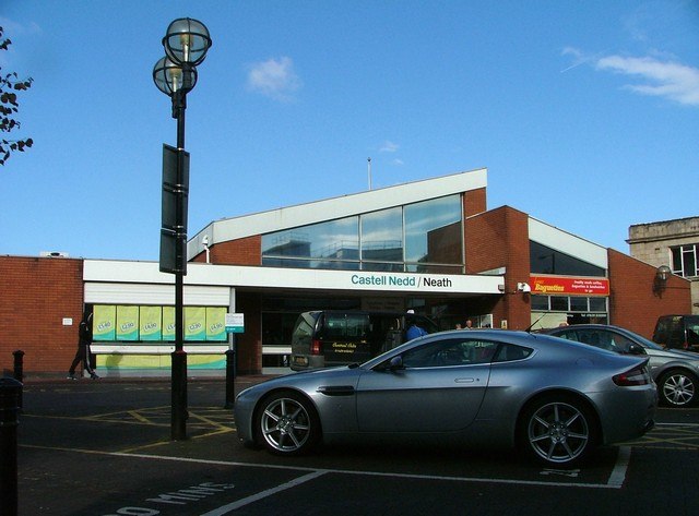
Photo: Alan Roberts, CC BY-SA 2.0.
Neath railway station is a main line railway station serving the town of Neath, south Wales. Managed by Transport for Wales, the station is located at street level on Windsor Road, situated back from the street fronting a small car park.
Neath Castle
Castle
Neath Castle is a Norman castle located in the town centre of Neath, Wales. Its construction was begun by Robert, Earl of Gloucester, the nominal Lord of Glamorgan, at a date estimated between 1114 and 1130.
Victoria Gardens
Park

Photo: Jaggery, CC BY-SA 2.0.
The Victoria Gardens, in the town centre of Neath, Wales, is a Grade II registered park on the Cadw/ICOMOS Register of Parks and Gardens of Special Historic Interest in Wales.
Places in the Area
Nearby places include Afan Forest Park and Port Talbot.
Afan Forest Park

Photo: Rude Health, CC BY-SA 2.0.
The Afan Forest Park is a 48-square-mile forest park in Wales. It is set in the Afan Valley in Neath Port Talbot. It is well known for its mountain biking and hiking or hillwalking trails. It is situated seven miles from Junction 40 of the M4.
Port Talbot

Photo: Kevin Corcoran, CC BY-SA 2.0.
Port Talbot is an industrial town in South Wales. It is located in the county borough of Neath Port Talbot, part of the traditional county of Glamorgan and has a population of around 32,000.
Briton Ferry
Town
Photo: Steve Rigg, CC BY-SA 2.0.
Briton Ferry is a town and community in the county borough of Neath Port Talbot, Wales. The Welsh name may indicate that the church, llan, is protected from the wind, awel.
Cimla Hill
- Type: Peak with an elevation of 561 feet
- Category: landform
- Location: Neath, Neath Port Talbot, Wales, United Kingdom, Britain and Ireland, Europe
- View on OpenStreetMap
Latitude
51.6464° or 51° 38′ 47″ northLongitude
-3.7815° or 3° 46′ 54″ westElevation
561 feet (171 metres)Open location code
9C3RJ6W9+H9OpenStreetMap ID
node 3600822075OpenStreetMap feature
natural=peak
This page is based on OpenStreetMap, Wikidata, and Wikimedia Commons.
We’d love your help improving our open data sources. Thank you for contributing.
Satellite Map
Discover Cimla Hill from above in high-definition satellite imagery.
Localities in the Area
Explore places such as Cimla and Efail-fach.
Notable Places Nearby
Highlights include Cefn Saeson and Cimla Fire Station.
Wales: Must-Visit Destinations
Delve into Cardiff, Swansea, Newport, and Llanfairpwllgwyngyll.
Curious Peaks to Discover
Uncover intriguing peaks from every corner of the globe.
About Mapcarta. Data © OpenStreetMap contributors and available under the Open Database License". Text is available under the CC BY-SA 4.0 license, except for photos, directions, and the map. Photo: fionamcallisterphotography, CC BY 2.0.