Cadover
Cadover is a locality in Meavy, West Devon District, England. Cadover is situated nearby to the locality Dunstone, as well as near Lower Cadworthy Farm.| Tap on a place to explore it |
Places of Interest
Highlights include Brisworthy stone circle and Ringmoor stone row and cairn circle.
Brisworthy stone circle

Photo: Richard Johns, CC BY-SA 2.0.
Brisworthy stone circle is a stone circle on Dartmoor, Devon. It is located three miles east of the A386, northeast of the village of Shaugh Prior. It is three hundred metres from Ringmoor stone row and cairn circle, and is one of the archaeological sites found in the Upper Plym Valley.
Ringmoor stone row and cairn circle
Archaeological site

Photo: Tomorrow Never Knows, CC BY 2.0.
Ringmoor stone row and cairn circle is a prehistoric stone row and cairn circle on Ringmoor Down in Devon. It is located three miles east of the A386, northeast of the village of Shaugh Prior.
Great Trowlesworthy Tor
Peak

Photo: Nilfanion, CC BY-SA 3.0.
Great Trowlesworthy Tor is a granite tor on the southwestern edge of Dartmoor. It is located near the popular Cadover Bridge and is a popular walking destination.
Places in the Area
Nearby places include Dousland and Roborough Rock.
Dousland
Village
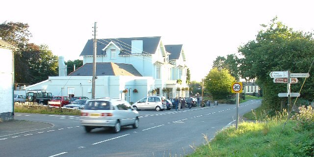
Photo: Pete Chapman, CC BY-SA 2.0.
Dousland is a small settlement in Devon, England. It is near the A386 road at Yelverton and is 10 kilometres northeast of the city of Plymouth - 10 kilometres by road. Dousland is situated 2½ miles northwest of Cadover.
Roborough Rock
Locality
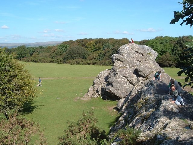
Photo: Mark Land, CC BY-SA 2.0.
Yelverton Rock is a tor-like igneous rock outcrop immediately south-west of Yelverton, Devon. It is located at the southern end of the former RAF Harrowbeer airfield on Roborough Down, next to the border with the A386. Roborough Rock is situated 3 miles northwest of Cadover.
Yelverton
Village
Photo: JThomas, CC BY-SA 2.0.
Yelverton is a large village on the south-western edge of Dartmoor, Devon, in England. It is in the civil parish of Buckland Monachorum. According to the 2021 census, it had a population of 1,858, which was slightly more than the 1,810 recorded at the 2011 census. Yelverton is situated 3 miles northwest of Cadover.
Cadover
- Type: Locality
- Location: Meavy, West Devon District, Dartmoor, Devon, West Country, England, United Kingdom, Britain and Ireland, Europe
- View on OpenStreetMap
Latitude
50.46342° or 50° 27′ 48″ northLongitude
-4.03697° or 4° 2′ 13″ westOpen location code
9C2QFX77+96OpenStreetMap ID
node 3650728954OpenStreetMap feature
place=locality
This page is based on OpenStreetMap, Wikidata, and Wikimedia Commons.
We’d love your help improving our open data sources. Thank you for contributing.
Satellite Map
Discover Cadover from above in high-definition satellite imagery.
Localities in the Area
Explore places such as Dunstone and Lower Cadworthy Farm.
Notable Places Nearby
Highlights include Cadworthy Wood and Wigford Down.
Dartmoor: Must-Visit Destinations
Delve into Tavistock, Ashburton, Okehampton, and Buckfastleigh.
Curious Localities to Discover
Uncover intriguing localities from every corner of the globe.
About Mapcarta. Data © OpenStreetMap contributors and available under the Open Database License". Text is available under the CC BY-SA 4.0 license, except for photos, directions, and the map. Photo: RobThinks, CC BY-SA 4.0.