Debbiaccia
Debbiaccia is a locality in Stazzema, Lucca, Tuscany. Debbiaccia is situated nearby to the locality Deglio, as well as near Tricella.| Tap on a place to explore it |
Places of Interest
Highlights include Monte Forato and Pania della Croce.
Monte Forato
Peak
 Monte Forato is a mountain in the Alpi Apuane, in Tuscany, central Italy. It is formed by two peaks of similar altitude, connected by a natural arch which has given the group its name.
Pania della Croce
Peak
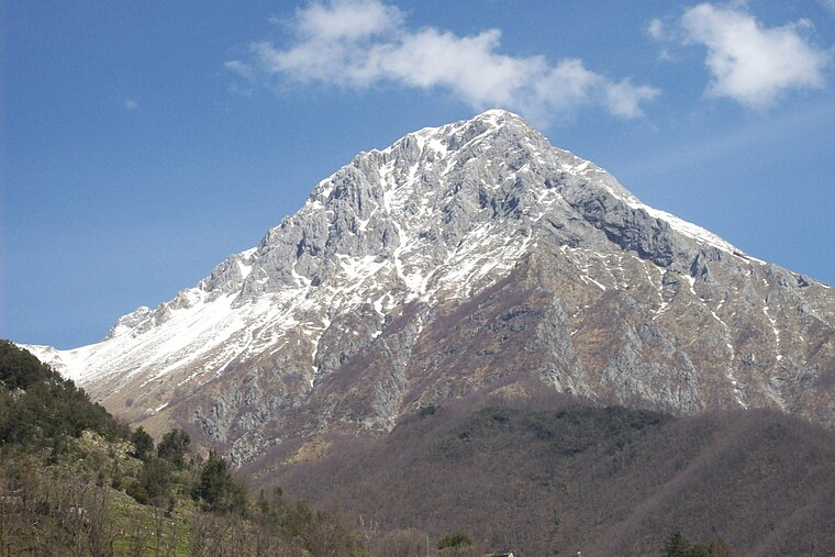
Photo: Vergaglia, Public domain.
Pania della Croce is a mountain in the Alpi Apuane, in Tuscany, central Italy. It is the highest peak in the Panie Group, located not far from the Tyrrhenian Sea coast.
Montalto
Peak

Photo: Retignano, CC BY-SA 4.0.
Montalto is a mountain located in Tuscany, Italy and part of the Apuan Alps range. Its highest peak is at roughly 913 meters above the sea level and it is also home of two villages, Retignano and Volegno, in the municipality of Stazzema, Province of Lucca.
Places in the Area
Nearby places include Pruno and Volegno.

Volegno
Hamlet

Photo: Wikimedia, Public domain.
Volegno is a village in Tuscany in central Italy. Administratively, it is a frazione of the comune of Stazzema, in the province of Lucca. Located at 430 m over the sea level in the Alpi Apuane Regional Park, it has 65 inhabitants.

Debbiaccia
- Type: Locality
- Location: Stazzema, Lucca, Tuscany, Central Italy, Italy, Europe
- View on OpenStreetMap
Latitude
44.01782° or 44° 1′ 4″ northLongitude
10.31705° or 10° 19′ 1″ eastOpen location code
8FPG2898+4ROpenStreetMap ID
node 3839234670OpenStreetMap feature
place=locality
This page is based on OpenStreetMap, Wikidata, and Wikimedia Commons.
We’d love your help improving our open data sources. Thank you for contributing.
Satellite Map
Discover Debbiaccia from above in high-definition satellite imagery.
Localities in the Area
Explore places such as Deglio and Tricella.
Notable Places Nearby
Highlights include Veduta della Cascata and Cascata dell‘ Acquapendente.
Lucca: Must-Visit Destinations
Delve into Lucca, Viareggio, Forte Dei Marmi, and Massarosa.
Curious Localities to Discover
Uncover intriguing localities from every corner of the globe.
About Mapcarta. Data © OpenStreetMap contributors and available under the Open Database License". Text is available under the CC BY-SA 4.0 license, except for photos, directions, and the map. Photo: Wikimedia, CC BY-SA 3.0.