Sylhet Sweets Store
Sylhet Sweets Store is a convenience store in Tower Hamlets, Greater London, England which is located on Hanbury Street. Sylhet Sweets Store is situated nearby to the community center Spitalfields Community Room, as well as near the locality Mile End New Town.| Tap on a place to explore it |
Places of Interest Nearby
Highlights include The Tower of London and Brick Lane.
The Tower of London

Photo: Aniacra, CC BY-SA 4.0.
The Tower of London, officially His Majesty's Royal Palace and Fortress of the Tower of London, is a historic citadel and castle on the north bank of the River Thames in London, England. The Tower of London is situated 1 mile south of Sylhet Sweets Store.
Brick Lane
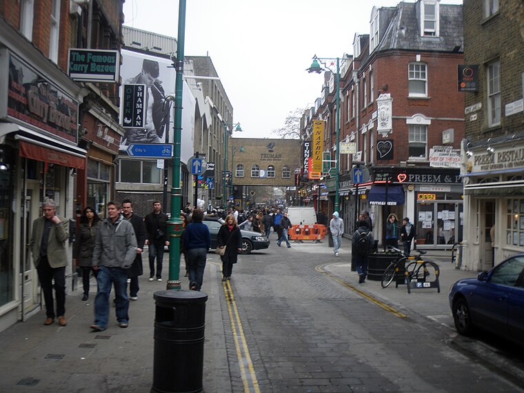
Photo: Gons, CC BY-SA 4.0.
Brick Lane is a street in the East End of London, in the borough of Tower Hamlets. It runs from Swanfield Street in Bethnal Green in the north, crosses the Bethnal Green Road before reaching the busiest, most commercially active part which runs through Spitalfields, or along its eastern edge. Brick Lane is situated 1,000 feet southwest of Sylhet Sweets Store.
London Bridge
 The name "London Bridge" refers to several historic crossings that have spanned the River Thames between the City of London and Southwark in central London since Roman times. London Bridge is situated 1¼ miles southwest of Sylhet Sweets Store.
Places in the Area
Nearby places include Mile End New Town and Whitechapel.
Mile End New Town
Locality
Mile End New Town is a former hamlet and then civil parish in the East End of London. Its former area is now part of the London Borough of Tower Hamlets.
Whitechapel
Suburb
 Whitechapel is an area in the London Borough of Tower Hamlets, London, England. It is in east London and part of the East End. It is the location of Tower Hamlets Town Hall and, therefore, the borough town centre.
Spitalfields
Quarter
Photo: Diliff, CC BY-SA 3.0.
Spitalfields is an area in London, England and is located in the London Borough of Tower Hamlets. It is in East London and situated in the East End. Spitalfields is formed around Commercial Street and Brick Lane.
Sylhet Sweets Store
- Type: Convenience store
- Address: 109 Hanbury Street, London, E1 5JQ
- Categories: shop and food
- Location: Tower Hamlets, Greater London, England, United Kingdom, Britain and Ireland, Europe
- View on OpenStreetMap
Latitude
51.51999° or 51° 31′ 12″ northLongitude
-0.06884° or 0° 4′ 8″ westOpen location code
9C3XGW9J+XFOpenStreetMap ID
node 3973507318OpenStreetMap feature
shop=convenience
This page is based on OpenStreetMap, Wikidata, and Wikimedia Commons.
We’d love your help improving our open data sources. Thank you for contributing.
Satellite Map
Discover Sylhet Sweets Store from above in high-definition satellite imagery.
Notable Places Nearby
Highlights include Spitalfields Community Room and Saint Anne’s.
Nearby Places
Explore places such as Xhibit Homes and Al Amin Cash & Carry.
England: Must-Visit Destinations
Delve into London, Manchester, Sheffield, and Leeds.
Curious Convenience Stores to Discover
Uncover intriguing convenience stores from every corner of the globe.
About Mapcarta. Data © OpenStreetMap contributors and available under the Open Database License". Text is available under the CC BY-SA 4.0 license, except for photos, directions, and the map. Photo: sidibousaid, CC BY 2.0.