Butchershole
Butchershole is a parking area in East Dean and Friston, Wealden District, England. Butchershole is situated nearby to the historic building Friston Place, as well as near the peak Friston Hill.| Tap on a place to explore it |
Places of Interest Nearby
Highlights include Seven Sisters and The Parish Church of Saint Mary the Virgin.
Seven Sisters
Scenic viewpoint

Photo: StephenDawson, CC BY-SA 2.0.
The Seven Sisters are a series of chalk sea cliffs on the English Channel coast, and are a stretch of the sea-eroded section of the South Downs range of hills, in the county of East Sussex, in south-east England. Seven Sisters is situated 2 miles southwest of Butchershole.
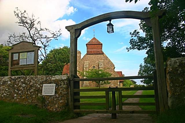
The Parish Church of Saint Mary the Virgin
Church

Photo: Michael Ford, CC BY-SA 2.0.
The Parish Church of Saint Mary the Virgin is situated 4,200 feet south of Butchershole.
Lullington Heath
Nature reserve

Photo: Kevin Gordon, CC BY-SA 2.0.
Lullington Heath is a 72.7-hectare biological Site of Special Scientific Interest west of Eastbourne in East Sussex. It is a national nature reserve and a Nature Conservation Review site, Grade I. Lullington Heath is situated 1½ miles northwest of Butchershole.
Places in the Area
Nearby places include Friston and Westdean.
Westdean
Village

Photo: Ian Cunliffe, CC BY-SA 2.0.
Westdean is a village, which is situated 2 miles west of Butchershole.
Litlington
Village

Photo: ArildV, CC BY-SA 4.0.
Litlington is a village and former civil parish, now in the parish of Cuckmere Valley, in the Wealden district, in the county of East Sussex, England. It is focussed 3 miles ENE of Seaford on the south coast. Litlington is situated 2½ miles northwest of Butchershole.
Butchershole
- Type: Parking area
- Category: transportation
- Location: East Dean and Friston, Wealden District, East Sussex, South East England, England, United Kingdom, Britain and Ireland, Europe
- View on OpenStreetMap
Latitude
50.77339° or 50° 46′ 24″ northLongitude
0.20456° or 0° 12′ 16″ eastOperator
Forestry ComissionOpen location code
9F22Q6F3+9ROpenStreetMap ID
node 401878636OpenStreetMap feature
amenity=parking
This page is based on OpenStreetMap, Wikidata, and Wikimedia Commons.
We’d love your help improving our open data sources. Thank you for contributing.
Satellite Map
Discover Butchershole from above in high-definition satellite imagery.
Notable Places Nearby
Highlights include Friston Place and Friston Hill.
Nearby Places
Explore places such as Friston Water Tower and BN20 0AR.
East Sussex: Must-Visit Destinations
Delve into Brighton, Eastbourne, Hastings, and Lewes.
Curious Parking Areas to Discover
Uncover intriguing parking areas from every corner of the globe.
About Mapcarta. Data © OpenStreetMap contributors and available under the Open Database License". Text is available under the CC BY-SA 4.0 license, except for photos, directions, and the map. Photo: matthewhartley369, CC BY-SA 2.0.