VAS ‘Latvijas dzelzceļš’
VAS ‘Latvijas dzelzceļš’ is a government office in Riga, Riga region which is located on Emīlijas Benjamiņas iela. VAS ‘Latvijas dzelzceļš’ is situated nearby to the government office Latvijas Valsts ceļi, as well as near Ministry of Transport of the Republic of Latvia.| Tap on a place to explore it |
- Opening hours: Monday—Friday 8:00 AM—noon and 1:00 PM—5:00 PM
- Type: Government office
- Address: Emīlijas Benjamiņas iela 3, Rīga, LV-1050
Places of Interest Nearby
Highlights include Central Market and Annunciation of Our Most Holy Lady Church.
Central Market
Marketplace

Photo: Wikimedia, CC BY-SA 3.0.
Riga Central Market is Europe's largest market and bazaar in Riga, Latvia. It is one of the most notable structures from 20th century in Latvia and has been included in UNESCO World Heritage Site list together with Old Riga in 1998. Central Market is situated 340 metres southwest of VAS ‘Latvijas dzelzceļš’.
Annunciation of Our Most Holy Lady Church
Church

Photo: Smig, CC BY-SA 3.0.
Annunciation of Our Most Holy Lady Church is an Orthodox church in Riga, the capital of Latvia. The church is situated at the address 9 Emilijas Benjamiņas Street. Annunciation of Our Most Holy Lady Church is situated 180 metres southeast of VAS ‘Latvijas dzelzceļš’.
Riga Central Station
Station
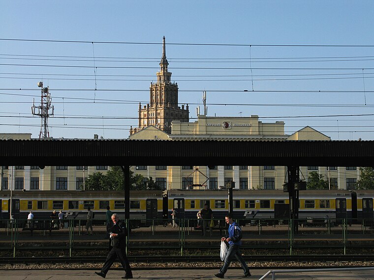
Photo: Philipp Hertzog, CC BY-SA 3.0.
Riga Central Station is the main railway station in Riga, Latvia. It is known as the main point of Riga due to its central location, and most forms of public transport stop in this area. Riga Central Station is situated 190 metres northwest of VAS ‘Latvijas dzelzceļš’.
Places in the Area
Nearby places include Vecrīga and Bastion Hill.
Vecrīga
 Old Riga — Vecrīga in Latvian — is the old town of Riga. Vecrīga is famous for its old churches and cathedrals, such as Riga Cathedral and St. Peter's Church. Vecrīga is one of two world heritage sites entirely situated in Latvia.
Bastion Hill
Locality
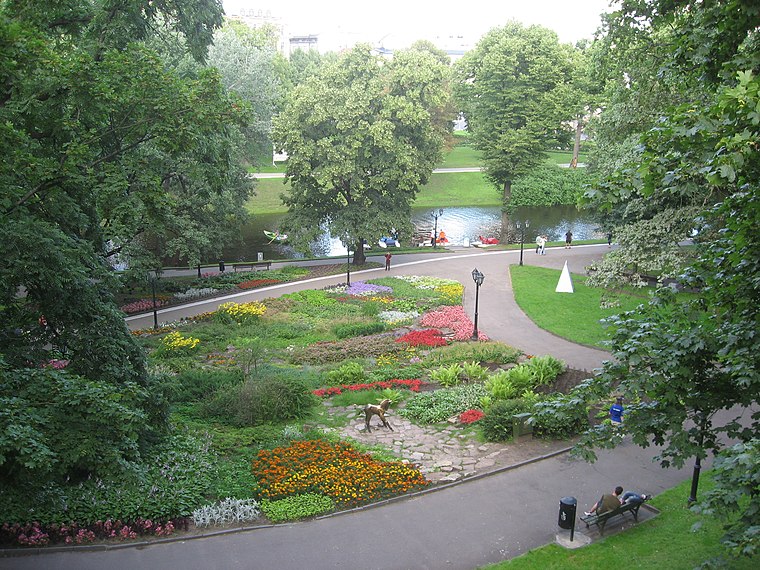
Photo: Dezidor, CC BY-SA 2.5.
Bastejkalns Park is a spacious park on the eastern edge of the old town of Latvian capital Riga.
Centrs
 Centrs is a district in Riga, right northeast of the old town. In addition to the official Centrs district, this article also includes the northwesternmost third of Maskavas Forstate, west of Lacplesa iela.
VAS ‘Latvijas dzelzceļš’
- Categories: office and government building
- Location: Riga, Riga region, Latvia, Baltic states, Europe
- View on OpenStreetMap
Latitude
56.94536° or 56° 56′ 43″ northLongitude
24.1216° or 24° 7′ 18″ eastOpen location code
9G86W4WC+4JOpenStreetMap ID
node 4130421489OpenStreetMap feature
office=government
This page is based on OpenStreetMap, Wikidata, and Wikimedia Commons.
We’d love your help improving our open data sources. Thank you for contributing.
Satellite Map
Discover VAS ‘Latvijas dzelzceļš’ from above in high-definition satellite imagery.
Notable Places Nearby
Highlights include Latvijas Valsts ceļi and Ministry of Transport of the Republic of Latvia.
Nearby Places
Explore places such as VCA poliklīnika DZELZCEĻŠ and Rail Baltica terminal.
Riga: Must-Visit Destinations
Delve into Vecrīga, Centrs, Outer East Bank, and Pārdaugava.
Curious Government Offices to Discover
Uncover intriguing government offices from every corner of the globe.
About Mapcarta. Data © OpenStreetMap contributors and available under the Open Database License". Text is available under the CC BY-SA 4.0 license, except for photos, directions, and the map. Photo: Poco a poco, CC BY-SA 3.0.