Punto B
Punto B is a geographical marker in Natales, Última Esperanza Province, Region of Magallanes. Punto B is situated nearby to the peak Cerro Standhardt, as well as near Torre de la Medialuna.| Tap on a place to explore it |
Places of Interest Nearby
Highlights include Cerro Torre and Cerro Standhardt.
Cerro Torre
Peak

Photo: Stefan.straub, CC BY-SA 4.0.
Cerro Torre is one of the mountains of the Southern Patagonian Ice Field in South America. It is located on the border dividing Argentina and Chile, west of Fitz Roy.
Cerro Standhardt
Peak
The Cerro Standhardt is a mountain within the disputed area between Chile and Argentina. It is the third highest of a chain of four peaks, which also includes Cerro Torre, Torre Egger, and Herron Point.
Torre Egger
Peak
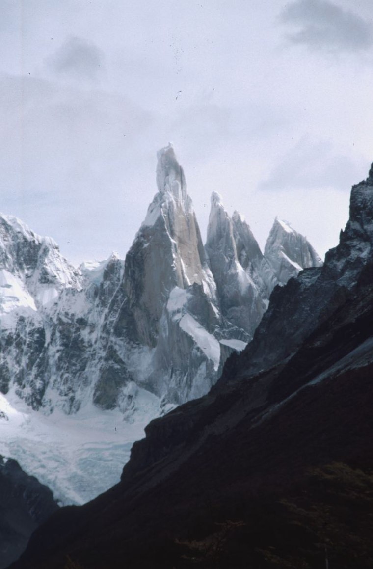
Photo: Christof01, CC BY-SA 3.0.
Torre Egger is one of the peaks in the Southern Patagonian Ice Field in South America, located between Argentina and Chile, west of Cerro Chalten. Torre Egger lies between Cerro Torre, the highest in a four mountain chain and Cerro Standhardt.
Places in the Area
Nearby places include Chaltén Mountain Range Natural Site, Chile and Circo de los Altares.
Chaltén Mountain Range Natural Site, Chile
Locality

Photo: Wikimedia, CC BY-SA 4.0.
The Chaltén Mountain Range Natural Site is a natural site part of the Bernardo O'Higgins National Park in the Magallanes and Chilean Antarctica Region, Chile.
Circo de los Altares
Locality

Photo: Juan Francisco Bustos, CC BY-SA 2.0.
The Circo de los Altares is a cirque glacier of the Patagonian Andes, located in the Southern Patagonian Ice Field, where Cerro Torre and Mount Fitz Roy can be seen from its western sides. Circo de los Altares is situated 3 km west of Punto B.
Punto B
- Type: Geographical marker
- Category: historic site
- Location: Natales, Última Esperanza Province, Region of Magallanes, Chile, South America
- View on OpenStreetMap
Latitude
-49.28389° or 49° 17′ 2″ southLongitude
-73.08667° or 73° 5′ 12″ westOpen location code
4728PW87+C8OpenStreetMap ID
node 4139610189OpenStreetMap feature
historic=boundary_stone
This page is based on OpenStreetMap, Wikidata, and Wikimedia Commons.
We’d love your help improving our open data sources. Thank you for contributing.
Satellite Map
Discover Punto B from above in high-definition satellite imagery.
Notable Places Nearby
Highlights include Torre de la Medialuna and Punta Herron.
Nearby Places
Explore places such as Circo De Los Altares and Swiss Bivy.
Chile: Must-Visit Destinations
Delve into Central Chile, Santiago, Valparaíso, and Concepción.
Curious Geographical Markers to Discover
Uncover intriguing geographical markers from every corner of the globe.
About Mapcarta. Data © OpenStreetMap contributors and available under the Open Database License". Text is available under the CC BY-SA 4.0 license, except for photos, directions, and the map. Photo: Berberismicrophylla, CC BY-SA 4.0.