Wineflair North Queen Street
Wineflair North Queen Street is a liquor store in Belfast, County Antrim, Northern Ireland which is located on North Queen Street. Wineflair North Queen Street is situated nearby to the playground The Mount Sports Zone, as well as near the church St Pauls & St Barnabas.| Tap on a place to explore it |
Places of Interest Nearby
Highlights include York Street railway station and SS Nomadic.
York Street railway station
Railway station
York Street railway station serves the north of Belfast in Northern Ireland. The station replaced Yorkgate railway station, which was on a nearby site and closed after the last train on 27 April 2024. York Street railway station is situated 1,200 feet southeast of Wineflair North Queen Street.
SS Nomadic
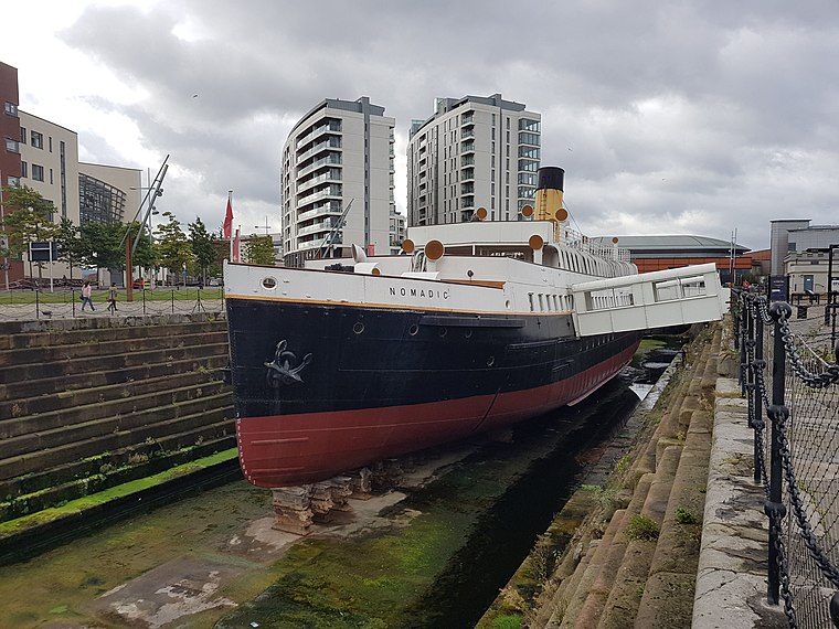
Photo: Irid Escent, CC BY-SA 2.0.
SS Nomadic is a former tender of the White Star Line, launched on 25 April 1911 at Belfast, that is now on display in Belfast's Titanic Quarter. She was built to transfer passengers and mail to and from the ocean liners RMS Olympic and RMS Titanic. SS Nomadic is situated 3,900 feet southeast of Wineflair North Queen Street.
Titanic Belfast

Photo: Wikimedia, CC BY-SA 4.0.
Titanic Belfast is a visitor attraction in Northern Ireland, which opened in 2012. A monument to Belfast's maritime heritage on the site of the former Harland & Wolff shipyard in the city's Titanic Quarter where the RMS Titanic was built. Titanic Belfast is situated 3,800 feet east of Wineflair North Queen Street.
Places in the Area
Nearby places include New Lodge and Cathedral Quarter.
New Lodge
Suburb

Photo: Gerry Lynch, CC BY 2.5.
The New Lodge is an urban, working class Catholic community in Belfast, Northern Ireland, immediately to the north of the city centre. The landscape is dominated by several large tower blocks.
Cathedral Quarter
Quarter

Photo: Stuart, CC BY-SA 2.0.
The Cathedral Quarter in Belfast, Northern Ireland, is a developing area of the city, roughly situated between Royal Avenue near where the Belfast Central Library building is, and the Dunbar Link in the city centre.
Titanic Quarter
Quarter
Photo: Wikimedia, CC BY-SA 4.0.
Titanic Quarter in Belfast, Northern Ireland, is a large-scale waterfront regeneration, comprising historic maritime landmarks, film studios, education facilities, apartments, a riverside entertainment district, and the world's largest Titanic-themed attraction centred on land in Belfast Harbour, known until 1995 as Queen's Island, and initially, Dargan's Island.
Wineflair North Queen Street
- Type: Liquor store
- Address: North Queen Street, Belfast, BT15 1HQ
- Category: shop
- Location: Belfast, County Antrim, Northern Ireland, United Kingdom, Britain and Ireland, Europe
- View on OpenStreetMap
Latitude
54.61206° or 54° 36′ 43″ northLongitude
-5.92683° or 5° 55′ 37″ westOperator
WineflairOpen location code
9C6PJ36F+R7OpenStreetMap ID
node 4377169311OpenStreetMap feature
shop=alcohol
This page is based on OpenStreetMap, Wikidata, and Wikimedia Commons.
We’d love your help improving our open data sources. Thank you for contributing.
Satellite Map
Discover Wineflair North Queen Street from above in high-definition satellite imagery.
Notable Places Nearby
Highlights include The Mount Sports Zone and St Pauls & St Barnabas.
Nearby Places
Explore places such as McKenzies Chemist and The Group Surgery.
County Antrim: Must-Visit Destinations
Delve into Giant’s Causeway, Lisburn, Ballymena, and Larne.
Curious Liquor Stores to Discover
Uncover intriguing liquor stores from every corner of the globe.
About Mapcarta. Data © OpenStreetMap contributors and available under the Open Database License". Text is available under the CC BY-SA 4.0 license, except for photos, directions, and the map. Photo: AlasdairW, CC BY-SA 3.0.