Footsteps to the Future
Footsteps to the Future is a work of art in Spokane, Washington. Footsteps to the Future is situated nearby to the scenic viewpoint Lower Falls, as well as near Monroe Street Bridge.| Tap on a place to explore it |
Places of Interest Nearby
Highlights include Monroe Street Bridge and Spokane County Courthouse.
Monroe Street Bridge
Bridge
 The Monroe Street Bridge is a deck arch bridge in the northwestern United States that spans the Spokane River in Spokane, Washington. It was built 114 years ago in 1911 by the city of Spokane, and was designed by city engineer John Chester Ralston, assisted in construction supervision by Morton Macartney with ornamentation provided by the firm of Kirtland Kelsey Cutter and Karl G. Monroe Street Bridge is situated 490 feet south of Footsteps to the Future.
Spokane County Courthouse
Courthouse
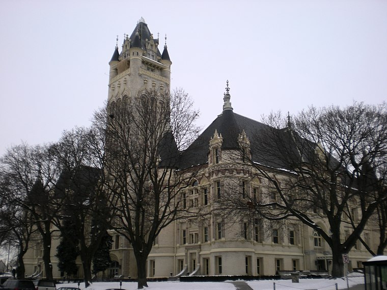
Photo: Murderbike, Public domain.
The Spokane County Courthouse is a government building home to numerous Spokane County offices such as those of the assessor, auditor and clerk, as well as courtrooms for the Spokane County Superior Court. Spokane County Courthouse is situated 1,200 feet northwest of Footsteps to the Future.
River Park Square
Shopping center

Photo: HumanisticRationale, CC BY 3.0.
River Park Square is a shopping mall and entertainment complex in Spokane, Washington. The shopping center was originally opened in 1974. Following years of decline, the center was redeveloped in 1999 using public and private funds in an effort to revitalize downtown Spokane. River Park Square is situated 1,200 feet southeast of Footsteps to the Future.
Places in the Area
Nearby places include Spokane and Peaceful Valley.
Spokane

Photo: Jdubman, CC BY-SA 3.0.
Spokane is the second-largest city in Washington State, and the largest between Seattle and Minneapolis. It is the economic hub of the "Inland Empire", a name used for Eastern Washington and the Idaho Panhandle. it as at the north edge of the Palouse, where gently rolling hills of wheat fields end at the Spokane River valley.
Peaceful Valley
Quarter
Peaceful Valley is a neighborhood in Spokane, Washington. It sits directly below Downtown Spokane on the Spokane River under its falls. The neighborhood snakes along the thin floodplain on the valley floor of the Spokane River Gorge.
Browne’s Addition
Quarter
Browne's Addition, often referred to shorthand as just Browne's, is a neighborhood in Spokane, Washington. It is located directly west of Downtown Spokane and is one of the oldest and densest neighborhoods in the city.
Footsteps to the Future
- Type: Work of art
- Artwork type: statue
- Category: tourism
- Location: Spokane, Washington, Pacific Northwest, United States, North America
- View on OpenStreetMap
Latitude
47.6621° or 47° 39′ 44″ northLongitude
-117.42635° or 117° 25′ 35″ westInception
2009Open location code
85V4MH6F+RFOpenStreetMap ID
node 4567182213OpenStreetMap feature
tourism=artworkOpenStreetMap attribute
artwork_type=statue
This page is based on OpenStreetMap, Wikidata, and Wikimedia Commons.
We’d love your help improving our open data sources. Thank you for contributing.
Satellite Map
Discover Footsteps to the Future from above in high-definition satellite imagery.
Notable Places Nearby
Highlights include Lower Falls and Huntington Park.
Nearby Places
Explore places such as Monroe @ Summit Parkway and Monroe @ Summit.
Washington: Must-Visit Destinations
Delve into Seattle, Olympia, Tacoma, and Spokane.
Curious Work Of Arts to Discover
Uncover intriguing work of arts from every corner of the globe.
About Mapcarta. Data © OpenStreetMap contributors and available under the Open Database License". Text is available under the CC BY-SA 4.0 license, except for photos, directions, and the map. Photo: Lumpytrout, CC BY-SA 3.0.