Young-Ellis Food Center
Young-Ellis Food Center is a convenience store in San Francisco, Bay Area, California which is located on Ellis Street. Young-Ellis Food Center is situated nearby to the post office USPS General Delivery, as well as near the church YVAM San Francisco.| Tap on a place to explore it |
- Type: Convenience store
- Also known as: “Ellis Produce”, “The Ellis Food Center”, and “Young-Ellis Produce”
- Address: 396 Ellis Street, San Francisco, CA
Places of Interest Nearby
Highlights include Boeddeker Park and Curran Theatre.
Boeddeker Park
Park
 Boeddeker Park, more formally known as Father Alfred E. Boeddeker Park, is an urban park in the Tenderloin neighborhood of San Francisco. This 1-acre park was renovated and reopened in 2014, especially intended to serve the needs of people in the surrounding neighborhood who experience amongst the highest levels of poverty in the city.
Curran Theatre
Theater building
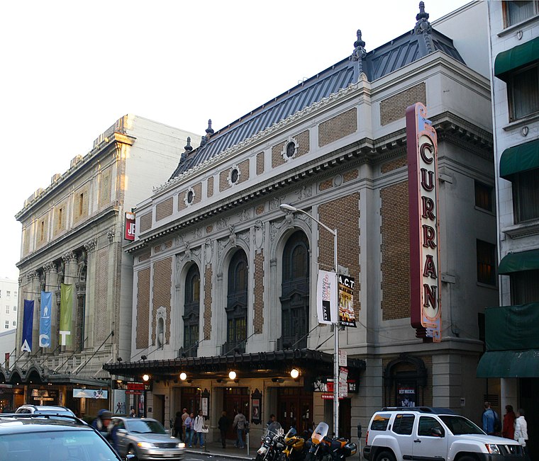 The Curran Theatre, located at 445 Geary Street between Taylor and Mason Streets in the Theatre District of San Francisco, California opened in February 1922, and was named after its first owner, Homer Curran. Curran Theatre is situated 890 feet northeast of Young-Ellis Food Center.
Glide Memorial Church
Church

Photo: Figlinus, CC BY-SA 4.0.
Glide Memorial Church is a nondenominational church in San Francisco, California, which opened in 1930. Since the 1960s, it has served as a counter-culture rallying point, as one of the most prominently liberal churches in the United States. Glide Memorial Church is situated 360 feet east of Young-Ellis Food Center.
Places in the Area
Nearby places include Tenderloin and Civic Center-Tenderloin.
Tenderloin
Quarter
 The Tenderloin is a neighborhood in downtown San Francisco, in the flatlands on the southern slope of Nob Hill, situated between the Union Square shopping district to the northeast and the Civic Center office district to the southwest.
Civic Center-Tenderloin

Photo: Almonroth, CC BY-SA 3.0.
As the name implies, the Civic Center is the primary center of government within San Francisco, housing many important civic institutions. Aside from its official duties, it also moonlights as a cultural center with many fine museums, theaters, opera houses, and symphony halls located here.
Lower Nob Hill Apartment Hotel District
Neighborhood

Photo: Sanfranman59, CC BY-SA 3.0.
The Lower Nob Hill Apartment Hotel District is a historic district located in downtown San Francisco, California, in an area that sits between the Nob Hill and Tenderloin neighborhoods.
Young-Ellis Food Center
- Categories: shop and food
- Location: San Francisco, Bay Area, California, United States, North America
- View on OpenStreetMap
Latitude
37.785° or 37° 47′ 6″ northLongitude
-122.41269° or 122° 24′ 46″ westOpen location code
849VQHPP+2WOpenStreetMap ID
node 4631708920OpenStreetMap feature
shop=convenience
This page is based on OpenStreetMap, Wikidata, and Wikimedia Commons.
We’d love your help improving our open data sources. Thank you for contributing.
Satellite Map
Discover Young-Ellis Food Center from above in high-definition satellite imagery.
Notable Places Nearby
Highlights include USPS General Delivery and YVAM San Francisco.
Nearby Places
Explore places such as Riviera Hotel and Cinnabar.
San Francisco: Must-Visit Destinations
Delve into Golden Gate, Chinatown-North Beach, Civic Center-Tenderloin, and Fisherman’s Wharf.
Curious Convenience Stores to Discover
Uncover intriguing convenience stores from every corner of the globe.
About Mapcarta. Data © OpenStreetMap contributors and available under the Open Database License". Text is available under the CC BY-SA 4.0 license, except for photos, directions, and the map. Photo: Wikimedia, CC BY-SA 3.0.