Ministerio de Sanidad, Servicios Sociales e Igualdad
Ministerio de Sanidad, Servicios Sociales e Igualdad is a government office in Salamanca, Madrid, Community of Madrid which is located on Calle de Alcalá. Ministerio de Sanidad, Servicios Sociales e Igualdad is situated nearby to the government office Ministerio de Empleo, as well as near the art gallery Galería de arte y Sala de Subastas Ansorena.| Tap on a place to explore it |
Places of Interest Nearby
Highlights include Puerta de Alcalá and Biblioteca Nacional de España.
Puerta de Alcalá

Photo: Enric, CC BY-SA 4.0.
The Puerta de Alcalá is a Neo-classical gate in the Plaza de la Independencia in Madrid, Spain. It was a gate of the former Walls of Philip IV. It stands near the city center and several meters away from the main entrance to the Parque del Buen Retiro. Puerta de Alcalá is situated 150 metres east of Ministerio de Sanidad, Servicios Sociales e Igualdad.
Biblioteca Nacional de España
Library
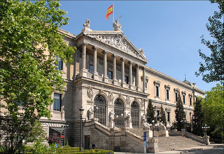 The Biblioteca Nacional de España is the national library of Spain. It is the largest public library in the country, and one of the largest in the world. Biblioteca Nacional de España is situated 470 metres north of Ministerio de Sanidad, Servicios Sociales e Igualdad.
city hall Palacio de Comunicaciones
Public building

Photo: Kadellar, CC BY-SA 3.0.
Cibeles Palace, formally known as Palacio de Comunicaciones and Palacio de Telecomunicaciones until 2011, is a complex composed of two buildings with white facades and is located in one of the historical centres of Madrid, Spain. city hall Palacio de Comunicaciones is situated 150 metres southwest of Ministerio de Sanidad, Servicios Sociales e Igualdad.
Places in the Area
Nearby places include Jerónimos and Recoletos.
Jerónimos
Quarter

Photo: Brian Adamson, CC BY 2.0.
Los Jerónimos is an administrative neighborhood of Madrid belonging to the district of Retiro. It is 1.900627 km² in size. The Retiro Park, the Town Hall and the Prado Museum are located within its limits.
Recoletos
Quarter

Photo: Rubén Vique, CC BY 2.0.
Recoletos is one of the six wards of Salamanca in Madrid, Spain.
Justicia
Quarter
 Justicia is a ward of Madrid belonging to the district of Centro. It contains the neighborhoods of Chueca and Salesas.
Ministerio de Sanidad, Servicios Sociales e Igualdad
- Type: Government office
- Address: Calle de Alcalá 56, Madrid, 28014
- Categories: office and government building
- Location: Salamanca, Madrid, Madrid, Community of Madrid, Central Spain, Spain, Iberia, Europe
- View on OpenStreetMap
Latitude
40.4195° or 40° 25′ 10″ northLongitude
-3.69036° or 3° 41′ 25″ westOpen location code
8CGRC895+QVOpenStreetMap ID
node 4648352029OpenStreetMap feature
office=government
This page is based on OpenStreetMap, Wikidata, and Wikimedia Commons.
We’d love your help improving our open data sources. Thank you for contributing.
Satellite Map
Discover Ministerio de Sanidad, Servicios Sociales e Igualdad from above in high-definition satellite imagery.
Places with the Same Name
Discover other places named “Ministerio de Sanidad, Servicios Sociales e Igualdad”.
Notable Places Nearby
Highlights include Ministerio de Empleo and Galería de arte y Sala de Subastas Ansorena.
Nearby Places
Explore places such as Vait Alcalá Pastelería and Caixabank.
Madrid: Must-Visit Destinations
Delve into Sol-Letras-Lavapiés, Salamanca, Retiro-Paseo del Arte, and Chamberí-Castellana.
Curious Government Offices to Discover
Uncover intriguing government offices from every corner of the globe.
About Mapcarta. Data © OpenStreetMap contributors and available under the Open Database License". Text is available under the CC BY-SA 4.0 license, except for photos, directions, and the map. Photo: DonPaolo, CC BY-SA 3.0.