Steyne Road
Steyne Road is a bus stop in Ealing, Greater London, England. Steyne Road is situated nearby to the town Acton, as well as near the park The Woodlands.| Tap on a place to explore it |
Places of Interest Nearby
Highlights include Library for Iranian Studies and Acton Hill Church.
Library for Iranian Studies
Library
Library for Iranian Studies is a major Persian library in Acton district of London, England. It has over 30,000 books in the Persian language, as well as English and other languages. The library receives no governmental funding and is voluntary controlled. Library for Iranian Studies is situated 370 feet south of Steyne Road.
Acton Hill Church
Church
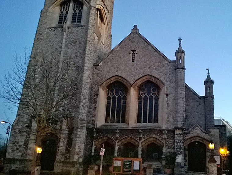
Photo: Bándíttos, CC BY-SA 4.0.
Acton Hill Church is situated 370 feet west of Steyne Road.
Acton Central railway station
Railway station

Photo: Sunil060902, CC BY-SA 3.0.
Acton Central is a station on the Mildmay line of the London Overground, situated between South Acton and Willesden Junction stations in Travelcard Zone 3. Acton Central railway station is situated 2,600 feet east of Steyne Road.
Places in the Area
Nearby places include Acton and Chiswick.
Acton
Town
Photo: Patche99z, Public domain.
Acton is a town in West London, England, within the London Borough of Ealing. It is 6.1 miles west of Charing Cross. At the 2011 census, its four wards, East Acton, Acton Central, South Acton and Southfield, had a population of 62,480, a ten-year increase of 8,791 people. North Acton, West Acton, East Acton, South Acton, Acton Green, Acton Town, Acton Vale and Acton Central are all parts of Acton.
Chiswick
Town
Photo: Patche99z, Public domain.
Chiswick is a district in West London, split between the London Boroughs of Hounslow and Ealing. It contains Hogarth's House, the former residence of the 18th-century English artist William Hogarth, Chiswick House, a neo-Palladian villa regarded as one of the finest in England and Fuller's Brewery, London's largest and oldest brewery.
Hammersmith and Fulham

Photo: Chmee2, CC BY-SA 3.0.
Hammersmith & Fulham is a borough in west London, and boasts 3 Premiership football teams within its boundaries.
Steyne Road
- Type: Bus stop
- Category: transportation
- Location: Ealing, Greater London, England, United Kingdom, Britain and Ireland, Europe
- View on OpenStreetMap
Latitude
51.50805° or 51° 30′ 29″ northLongitude
-0.27406° or 0° 16′ 27″ westOpen location code
9C3XGP5G+69OpenStreetMap ID
node 469771243OpenStreetMap feature
highway=bus_stopOpenStreetMap feature
public_transport=platform
This page is based on OpenStreetMap, Wikidata, and Wikimedia Commons.
We’d love your help improving our open data sources. Thank you for contributing.
Satellite Map
Discover Steyne Road from above in high-definition satellite imagery.
Places with the Same Name
Discover other places named “Steyne Road”.
Notable Places Nearby
Highlights include The Woodlands and MPS Acton.
Nearby Places
Explore places such as 13 Roses and Acton General Store.
England: Must-Visit Destinations
Delve into London, Manchester, Sheffield, and Leeds.
Curious Bus Stops to Discover
Uncover intriguing bus stops from every corner of the globe.
About Mapcarta. Data © OpenStreetMap contributors and available under the Open Database License". Text is available under the CC BY-SA 4.0 license, except for photos, directions, and the map. Photo: sidibousaid, CC BY 2.0.