Park Lane / Victoria Road
Park Lane / Victoria Road is a bus stop in Enfield, Greater London, England. Park Lane / Victoria Road is situated nearby to Victoria Road Post Office, as well as near the mosque Mevlana Rumi.| Tap on a place to explore it |
Places of Interest Nearby
Highlights include Edmonton Green railway station and Tottenham Hotspur Stadium.
Edmonton Green railway station
Railway station

Photo: Sunil060902, CC BY-SA 3.0.
Edmonton Green is a station on the Weaver line of the London Overground, located in Edmonton in the London Borough of Enfield, north London. It is 8 miles 45 chains down the line from London Liverpool Street and is situated between Silver Street to the south and Bush Hill Park and Southbury to the north. Edmonton Green railway station is situated 2,000 feet northeast of Park Lane / Victoria Road.
Tottenham Hotspur Stadium
Stadium

Photo: Arne mueseler, CC BY-SA 3.0 de.
Tottenham Hotspur Stadium is a multi-purpose stadium in London, England. It is owned and operated by the Premier League club Tottenham Hotspur, replacing the club's previous ground, White Hart Lane. Tottenham Hotspur Stadium is situated 1¼ miles south of Park Lane / Victoria Road.
Silver Street railway station
Railway station
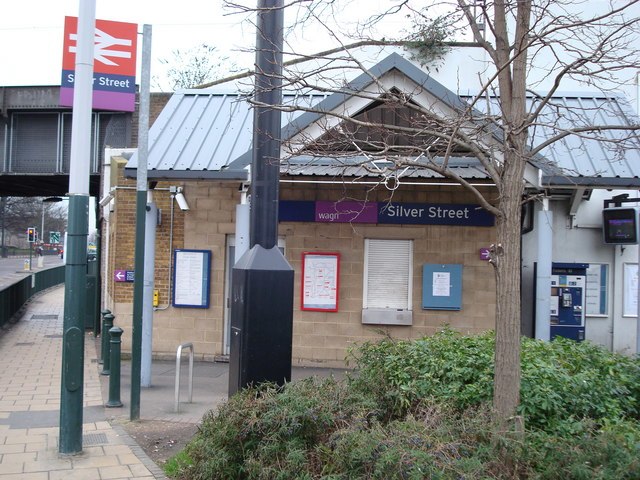
Photo: Stacey Harris, CC BY-SA 2.0.
Silver Street is a station on the Weaver line of the London Overground, located in Edmonton in the London Borough of Enfield, north London. It is 7 miles 75 chains down the line from London Liverpool Street and is situated between White Hart Lane and Edmonton Green stations. Silver Street railway station is situated 1,900 feet south of Park Lane / Victoria Road.
Places in the Area
Nearby places include Edmonton and Bush Hill Park.
Edmonton
Suburb

Photo: Nigel Cox, CC BY-SA 2.0.
Edmonton is a town in north London, England within the London Borough of Enfield, a local government district of Greater London. The northern part of the town is known as Lower Edmonton or Edmonton Green, and the southern part as Upper Edmonton.
Bush Hill Park
Neighborhood

Photo: Nigel Cox, CC BY-SA 2.0.
Bush Hill Park is an area of Enfield, located to the south-east of Enfield Town, on the outskirts of north London, and historically in Middlesex. Much of the district is a planned suburban estate, developed mainly in the late-19th and early-20th centuries, and designated a conservation area in 1986.
Tottenham
Town

Photo: Fin Fahey, CC BY-SA 2.0.
Tottenham is a district in north London, England, within the London Borough of Haringey. It is located in the ceremonial county of Greater London. Tottenham is centred 6 mi north-northeast of Charing Cross, bordering Edmonton to the north, Walthamstow, across the River Lea, to the east, and Stamford Hill to the south, with Wood Green and Harringay to the west. Tottenham is situated 1½ miles south of Park Lane / Victoria Road.
Park Lane / Victoria Road
- Type: Bus stop
- Category: transportation
- Location: Enfield, Greater London, England, United Kingdom, Britain and Ireland, Europe
- View on OpenStreetMap
Latitude
51.62054° or 51° 37′ 14″ northLongitude
-0.0672° or 0° 4′ 2″ westOpen location code
9C3XJWCM+64OpenStreetMap ID
node 469777806OpenStreetMap feature
highway=bus_stopOpenStreetMap feature
public_transport=platform
This page is based on OpenStreetMap, Wikidata, and Wikimedia Commons.
We’d love your help improving our open data sources. Thank you for contributing.
Satellite Map
Discover Park Lane / Victoria Road from above in high-definition satellite imagery.
Notable Places Nearby
Highlights include Victoria Road Post Office and Mevlana Rumi.
Nearby Places
Explore places such as Pymmes Park and Hyde Arms.
England: Must-Visit Destinations
Delve into London, Manchester, Sheffield, and Leeds.
Curious Bus Stops to Discover
Uncover intriguing bus stops from every corner of the globe.
About Mapcarta. Data © OpenStreetMap contributors and available under the Open Database License". Text is available under the CC BY-SA 4.0 license, except for photos, directions, and the map. Photo: sidibousaid, CC BY 2.0.