Ravenscourt Gardens
Ravenscourt Gardens is a bus stop in Hammersmith and Fulham, Greater London, England. Ravenscourt Gardens is situated nearby to the house The Brook, as well as near the park Stamford Brook Common.| Tap on a place to explore it |
Places of Interest Nearby
Highlights include Stamford Brook tube station and Turnham Green tube station.
Stamford Brook tube station
Metro station

Photo: Robin Sones, CC BY-SA 2.0.
Stamford Brook is a London Underground station on the eastern edge of Chiswick in west London. The station is served by the District line and is between Ravenscourt Park and Turnham Green stations. Stamford Brook tube station is situated 710 feet southwest of Ravenscourt Gardens.
Turnham Green tube station
Railway station
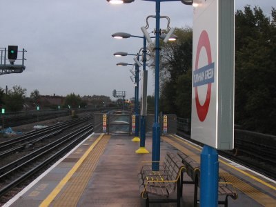
Photo: Wikimedia, CC BY-SA 3.0.
Turnham Green is a London Underground station in Chiswick of the London Borough of Hounslow, west London. It is served by the District and Piccadilly lines in a manner of cross-platform interchange, although Piccadilly line trains normally stop at the station only at the beginning and end of the day, running through non-stop at other times. Turnham Green tube station is situated 2,500 feet west of Ravenscourt Gardens.
Ravenscourt Park
Park

Photo: Peter Smyly, CC BY-SA 2.0.
Ravenscourt Park or RCP is an 8.3 hectares public park and garden located in the London Borough of Hammersmith and Fulham, England. It is one of the Borough's flagship parks, having won a Green Flag Award. Stamford Brook and Ravenscourt Park tube stations are close by. Ravenscourt Park is situated 1,100 feet east of Ravenscourt Gardens.
Places in the Area
Nearby places include Chiswick and Hammersmith.
Chiswick
Town
Photo: Patche99z, Public domain.
Chiswick is a district in West London, split between the London Boroughs of Hounslow and Ealing. It contains Hogarth's House, the former residence of the 18th-century English artist William Hogarth, Chiswick House, a neo-Palladian villa regarded as one of the finest in England and Fuller's Brewery, London's largest and oldest brewery.
Hammersmith
Suburb

Photo: Tarquin Binary, Public domain.
Hammersmith is a district of West London, England, 4.3 miles southwest of Charing Cross. It is the administrative centre of the London Borough of Hammersmith and Fulham, and identified in the London Plan as one of 35 major centres in Greater London.
Brook Green
Suburb

Photo: Chmee2, CC BY-SA 3.0.
Brook Green is an affluent sub-neighbourhood of Hammersmith in the London Borough of Hammersmith and Fulham. Located approximately 3.6 miles west of Charing Cross, it is bordered by Kensington, Holland Park, Shepherd's Bush, Hammersmith and Brackenbury Village.
Ravenscourt Gardens
- Type: Bus stop
- Category: transportation
- Location: Hammersmith and Fulham, Greater London, London, England, United Kingdom, Britain and Ireland, Europe
- View on OpenStreetMap
Latitude
51.49665° or 51° 29′ 48″ northLongitude
-0.2443° or 0° 14′ 40″ westOpen location code
9C3XFQW4+M7OpenStreetMap ID
node 469778001OpenStreetMap feature
highway=bus_stopOpenStreetMap feature
public_transport=platform
This page is based on OpenStreetMap, Wikidata, and Wikimedia Commons.
We’d love your help improving our open data sources. Thank you for contributing.
Satellite Map
Discover Ravenscourt Gardens from above in high-definition satellite imagery.
Notable Places Nearby
Highlights include The Brook and Stamford Brook Common.
Nearby Places
Explore places such as Chiswick Ambulance Station and Ravenscourt Gardens.
London: Must-Visit Destinations
Delve into South Kensington-Chelsea, Heathrow Airport, City of London, and Westminster.
Curious Bus Stops to Discover
Uncover intriguing bus stops from every corner of the globe.
About Mapcarta. Data © OpenStreetMap contributors and available under the Open Database License". Text is available under the CC BY-SA 4.0 license, except for photos, directions, and the map. Photo: Chmee2, CC BY-SA 3.0.