Dynevor Road
Dynevor Road is a bus stop in Richmond upon Thames, Greater London, England. Dynevor Road is situated nearby to the residential area Houblon’s Almshouses, as well as near King’s House School.| Tap on a place to explore it |
Places of Interest Nearby
Highlights include St Matthias Church, Richmond and First Church of Christ, Scientist, Richmond.
St Matthias Church, Richmond
Church

Photo: Norman21, CC BY-SA 3.0.
St Matthias Church is a Grade II listed Anglican church in Richmond, London. It was built in the Victorian Gothic style in 1857, and is described by Bridget Cherry and Nikolaus Pevsner as "the grandest church in Richmond". St Matthias Church, Richmond is situated 960 feet south of Dynevor Road.
First Church of Christ, Scientist, Richmond
Church

Photo: Oxyman, CC BY-SA 2.0.
First Church of Christ, Scientist, Richmond, is a church on Sheen Road, Richmond, London. It is a branch of The First Church of Christ, Scientist in Boston, Massachusetts, founded in 1879. First Church of Christ, Scientist, Richmond is situated 1,000 feet northwest of Dynevor Road.
Richmond station
Metro station

Photo: Wikimedia, CC BY-SA 3.0.
Richmond, also known as Richmond, is an interchange station in Richmond, Greater London on the Waterloo to Reading and North London lines in London fare zone 4. Richmond station is situated 1,700 feet northwest of Dynevor Road.
Places in the Area
Nearby places include Richmond and Richmond-Kew.
Richmond
Town
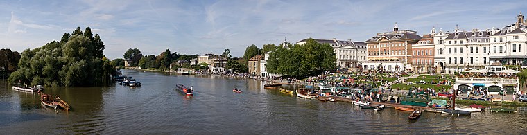
Photo: Diliff, CC BY-SA 3.0.
Richmond is a town in southwest London, 8.2 miles west-southwest of Charing Cross. It stands on the River Thames, and features many parks and open spaces, including Richmond Park, and many protected conservation areas, which include much of Richmond Hill.
Richmond-Kew

Photo: Diliff, CC BY-SA 3.0.
Richmond-Kew is a district in south-west London. This is perhaps the area of outer London with the most to offer visitors.
North Sheen
Suburb

Photo: Hassocks5489, Public domain.
North Sheen is an area of London, England in the former Municipal Borough of Richmond. It was incorporated into Kew in 1965 when the London Borough of Richmond upon Thames was created.
Dynevor Road
- Type: Bus stop
- Category: transportation
- Location: Richmond upon Thames, Greater London, England, United Kingdom, Britain and Ireland, Europe
- View on OpenStreetMap
Latitude
51.45926° or 51° 27′ 33″ northLongitude
-0.29648° or 0° 17′ 47″ westNetwork
London BusesOpen location code
9C3XFP53+PCOpenStreetMap ID
node 469782638OpenStreetMap feature
highway=bus_stopOpenStreetMap feature
public_transport=platform
This page is based on OpenStreetMap, Wikidata, and Wikimedia Commons.
We’d love your help improving our open data sources. Thank you for contributing.
Satellite Map
Discover Dynevor Road from above in high-definition satellite imagery.
Notable Places Nearby
Highlights include Houblon’s Almshouses and King’s House School.
Nearby Places
Explore places such as Dynevor Road and King’s House School.
England: Must-Visit Destinations
Delve into London, Manchester, Sheffield, and Leeds.
Curious Bus Stops to Discover
Uncover intriguing bus stops from every corner of the globe.
About Mapcarta. Data © OpenStreetMap contributors and available under the Open Database License". Text is available under the CC BY-SA 4.0 license, except for photos, directions, and the map. Photo: sidibousaid, CC BY 2.0.