Vanbrugh Park Road
Vanbrugh Park Road is a bus stop in Greenwich, Greater London, England. Vanbrugh Park Road is situated nearby to The John Roan School, as well as near the grassland The Dips.| Tap on a place to explore it |
Places of Interest Nearby
Highlights include Royal Observatory and Greenwich Park.
Royal Observatory
Museum

Photo: Wikimedia, CC BY-SA 3.0.
The Royal Observatory, Greenwich is an observatory situated on a hill in Greenwich Park in south east London, overlooking the River Thames to the north. Royal Observatory is situated 2,900 feet west of Vanbrugh Park Road.
Greenwich Park
Park
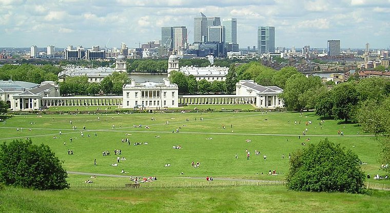
Photo: Sebjarod, Public domain.
Greenwich Park is a former hunting park in Greenwich and one of the largest single green spaces in south-east London. One of the eight Royal Parks of London, and the first to be enclosed, it covers 74 hectares, and is part of the Greenwich World Heritage Site.
National Maritime Museum
Museum

Photo: KTC, CC BY-SA 3.0.
The National Maritime Museum is a maritime museum in Greenwich, London. It is part of Royal Museums Greenwich, a network of museums in the Maritime Greenwich World Heritage Site. National Maritime Museum is situated 3,900 feet west of Vanbrugh Park Road.
Places in the Area
Nearby places include Blackheath Royal Standard and Greenwich.
Blackheath Royal Standard
Quarter

Photo: Chris Denny, CC BY-SA 2.0.
Blackheath Royal Standard is a quarter.
Greenwich
Town

Photo: KTC, CC BY-SA 4.0.
Greenwich is an area in south-east London, England, within the Royal Borough of Greenwich and the ceremonial county of Greater London, 5.5 miles east-south-east of Charing Cross.
Morden College
Neighborhood
 Morden College is a charity which has been providing residential care in Blackheath, south-east London, England for over 300 years. Founded by philanthropist Sir John Morden in 1695 as a home for "poor Merchants", Morden College was built to a design sometimes attributed to Sir Christopher Wren.
Vanbrugh Park Road
- Type: Bus stop
- Category: transportation
- Location: Greenwich, Greater London, London, England, United Kingdom, Britain and Ireland, Europe
- View on OpenStreetMap
Latitude
51.47871° or 51° 28′ 43″ northLongitude
0.0115° or 0° 0′ 41″ eastOpen location code
9F32F2H6+FHOpenStreetMap ID
node 469785862OpenStreetMap feature
highway=bus_stopOpenStreetMap feature
public_transport=platform
This page is based on OpenStreetMap, Wikidata, and Wikimedia Commons.
We’d love your help improving our open data sources. Thank you for contributing.
Satellite Map
Discover Vanbrugh Park Road from above in high-definition satellite imagery.
Notable Places Nearby
Highlights include The John Roan School and The Dips.
Nearby Places
Explore places such as Vanbrugh Park Road and John Roan School.
London: Must-Visit Destinations
Delve into South Kensington-Chelsea, Heathrow Airport, City of London, and Westminster.
Curious Bus Stops to Discover
Uncover intriguing bus stops from every corner of the globe.
About Mapcarta. Data © OpenStreetMap contributors and available under the Open Database License". Text is available under the CC BY-SA 4.0 license, except for photos, directions, and the map. Photo: Diliff, CC BY 3.0.