St Johns Grove Hilston Grove
St Johns Grove Hilston Grove is a bus stop in Kingston upon Hull, England. St Johns Grove Hilston Grove is situated nearby to John Hadland Park, as well as near the school building Liberty Academy.| Tap on a place to explore it |
Places of Interest Nearby
Highlights include Liberty Academy and Craven Park.
Liberty Academy
School building

Photo: Paul Harrop, CC BY-SA 2.0.
Liberty Academy, formerly Archbishop Sentamu Academy, is a mixed Church of England secondary school and sixth form located in the Preston Road Estate of Kingston upon Hull, England. Liberty Academy is situated 1,300 feet north of St Johns Grove Hilston Grove.
Craven Park
Stadium

Photo: Hullian111, CC BY-SA 4.0.
Craven Park is a rugby league stadium located in Kingston upon Hull, East Riding of Yorkshire, England. It is the home of Hull Kingston Rovers, one of two professional rugby league teams based in the city. Craven Park is situated 3,500 feet east of St Johns Grove Hilston Grove.
HM Prison Hull
Prison
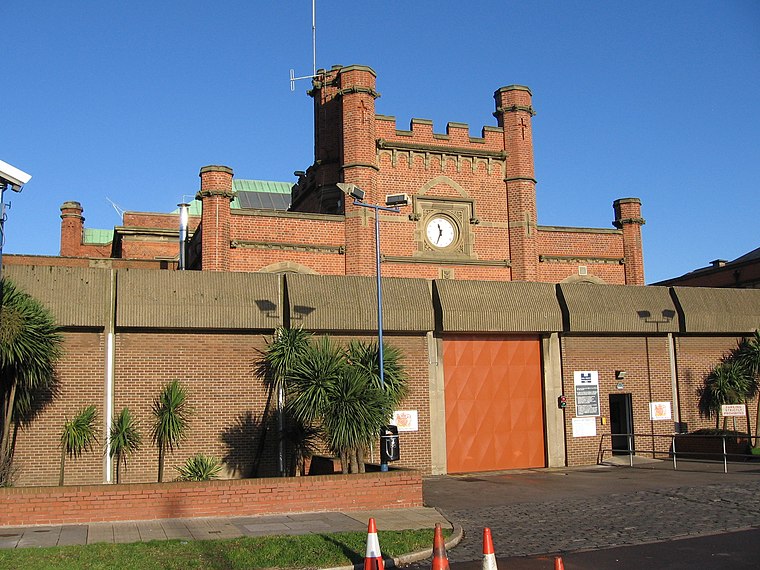 HMP Hull is a Category B men's local prison located in Kingston upon Hull in England. The term 'local' means that this prison holds people on remand to the local courts. The prison is operated by His Majesty's Prison Service. HM Prison Hull is situated 3,600 feet southwest of St Johns Grove Hilston Grove.
Places in the Area
Nearby places include Marfleet and Greatfield Estate.
Marfleet
Suburb
Photo: Paul Glazzard, CC BY-SA 2.0.
Marfleet is an area of Kingston upon Hull, East Riding of Yorkshire, England, in the east of the city, near King George Dock. Marfleet was until the late 20th century a small village outside the urban area of Hull – developments including the Hull and…
Greatfield Estate
Suburb
Greatfield Estate is a housing estate in the east of Kingston upon Hull, East Riding of Yorkshire. England, built in the late 1950s.
Summergangs
Suburb

Photo: Wikimedia, Public domain.
Summergangs is a suburb of Kingston upon Hull, near the A165 road, in the East Riding of Yorkshire, England. The area contains the model village development known as The Garden Village and East Park.
St Johns Grove Hilston Grove
- Type: Bus stop
- Category: transportation
- Location: Kingston upon Hull, England, United Kingdom, Britain and Ireland, Europe
- View on OpenStreetMap
Latitude
53.755° or 53° 45′ 18″ northLongitude
-0.28084° or 0° 16′ 51″ westOpen location code
9C5XQP49+2MOpenStreetMap ID
node 471490745OpenStreetMap feature
highway=bus_stop
This page is based on OpenStreetMap, Wikidata, and Wikimedia Commons.
We’d love your help improving our open data sources. Thank you for contributing.
Satellite Map
Discover St Johns Grove Hilston Grove from above in high-definition satellite imagery.
Notable Places Nearby
Highlights include John Hadland Park and Freedom Centre Library.
Nearby Places
Explore places such as St Johns Grove Harpham Grove and St Johns Grove Atwick Court.
England: Must-Visit Destinations
Delve into London, Manchester, Sheffield, and Leeds.
Curious Bus Stops to Discover
Uncover intriguing bus stops from every corner of the globe.
About Mapcarta. Data © OpenStreetMap contributors and available under the Open Database License". Text is available under the CC BY-SA 4.0 license, except for photos, directions, and the map. Photo: Wikimedia, CC0.