‘Electric Networks of Armenia’
‘Electric Networks of Armenia’ is an office in Armenia. ‘Electric Networks of Armenia’ is situated nearby to the hospital VitroMed, as well as near Nork-Marash Medical Center.| Tap on a place to explore it |
Places of Interest Nearby
Highlights include Nork-Marash Medical Center and Matenadaran.
Nork-Marash Medical Center
Hospital
The Nork-Marash Medical Center is a teaching hospital and biomedical research facility in Yerevan, Armenia, focused on cardiac care. It is led by Dr. Hrayr Hovagimian, a Syrian-Armenian cardiothoracic surgeon from the University of Aleppo and St. Vincent's Hospital, Portland. Nork-Marash Medical Center is situated 300 metres southeast of ‘Electric Networks of Armenia’.
Matenadaran
Museum
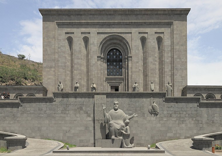
Photo: Halavar, CC BY-SA 4.0.
The Matenadaran, officially the Mesrop Mashtots Institute of Ancient Manuscripts, is the largest center for the storage, study and popularization of Armenian manuscripts, combining the functions of a museum, archive and scientific institution. Matenadaran is situated 1½ km northwest of ‘Electric Networks of Armenia’.
National Library of Armenia
Library

Photo: Գոհար Մարտիրոսյան, CC BY-SA 4.0.
The National Library of Armenia is a national public library in Yerevan, Armenia. It was founded in 1832 as part of the state gymnasium-school of Yerevan. National Library of Armenia is situated 1¼ km west of ‘Electric Networks of Armenia’.
Places in the Area
Nearby places include Yerevan and Kond.
Yerevan
 Yerevan is the capital of the Republic of Armenia, one of the three hubs of the South Caucasus and is home to over a million people — the largest Armenian community in the world.
Kond
Neighborhood

Photo: Stamboltsyan, Public domain.
Kond is one of the oldest quarters of Yerevan. It is situated within the boundaries of the modern-day Kentron District of the capital of Armenia. According to Hovhannes Shahkhatunyants, an Armenian historian, Kond is located at the western and southern hillsides and foot of a rocky hill with similar name. Kond is situated 3 km west of ‘Electric Networks of Armenia’.
Saritagh
Neighborhood

Photo: Kulmalukko, CC BY-SA 3.0.
Saritagh, is a neighbourhood in the Erebuni District of Yerevan, Armenia. Saritagh is situated 3 km south of ‘Electric Networks of Armenia’.
‘Electric Networks of Armenia’
Latitude
40.18651° or 40° 11′ 11″ northLongitude
44.53629° or 44° 32′ 11″ eastOpen location code
8HG65GPP+JGOpenStreetMap ID
node 4728182391OpenStreetMap feature
office=company
This page is based on OpenStreetMap, Wikidata, and Wikimedia Commons.
We’d love your help improving our open data sources. Thank you for contributing.
Satellite Map
Discover ‘Electric Networks of Armenia’ from above in high-definition satellite imagery.
In Other Languages
“‘Electric Networks of Armenia’” goes by many names.
- Russian: “‘ЭЛЕКТРИЧЕСКИЕ СЕТИ АРМЕНИИ’”
Notable Places Nearby
Highlights include VitroMed and Surb Astvatsatsin Church.
Nearby Places
Explore places such as ‘MAPLE LEAFS’ Armenian-Canadian Medical Clinic and Health Home.
Armenia: Must-Visit Destinations
Delve into Yerevan, Gyumri, Echmiadzin, and Vanadzor.
Curious Places to Discover
Uncover intriguing places from every corner of the globe.
About Mapcarta. Data © OpenStreetMap contributors and available under the Open Database License". Text is available under the CC BY-SA 4.0 license, except for photos, directions, and the map. Photo: Alexander Naumov, CC BY 3.0.