Legrams Lane Ingleby Road
Legrams Lane Ingleby Road is a bus stop in Bradford, England. Legrams Lane Ingleby Road is situated nearby to Church of Jesus Christ Apostolic Inc., as well as near the community center Ukrainian Community Centre.| Tap on a place to explore it |
Places of Interest Nearby
Highlights include Dixons Kings Academy and National Science and Media Museum.
Dixons Kings Academy
School
Dixons Kings Academy is a mixed free school for pupils aged 11 to 16 located in Bradford, West Yorkshire, England. The school opened as the Kings Science Academy in September 2011 and was one of the first free schools to open in England. Dixons Kings Academy is situated 1,600 feet west of Legrams Lane Ingleby Road.
National Science and Media Museum
Museum
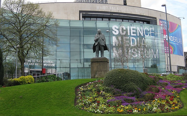
Photo: Chemical Engineer, CC BY-SA 4.0.
The National Science and Media Museum, located in Bradford, West Yorkshire, is part of the national Science Museum Group in the UK. The museum has seven floors of galleries with permanent exhibitions focusing on photography, television, animation, videogaming, the Internet and the scientific principles behind light and colour. National Science and Media Museum is situated 1 mile east of Legrams Lane Ingleby Road.
Horton Park
Park

Photo: NRTurner, CC BY-SA 4.0.
Horton Park is a public park in Bradford, England, located to the South of the city in Great Horton. It was opened on 25 May 1878 on land purchased by Bradford Council in 1873. Horton Park is situated 3,300 feet south of Legrams Lane Ingleby Road.
Places in the Area
Nearby places include Girlington and Manningham.
Girlington
Neighborhood
Girlington is an area in Bradford, West Yorkshire, England. Girlington is located to the west of Bradford city centre. The majority population of Girlington are of South Asian origin, in particular Pakistani, Afghan and Bangladeshi.
Manningham
Suburb
Photo: Shax, Public domain.
Manningham is a historically industrial workers area as well as a council ward of Bradford, West Yorkshire, England. The population of the 2011 Census for the Manningham Ward was 19,983.
Lister Mills
Locality

Photo: Wikimedia, Public domain.
Lister Mills was the largest silk factory in the world. It is located in the Manningham district of Bradford, West Yorkshire, England and was built by Samuel Cunliffe Lister to replace the original Manningham Mills which had been destroyed by fire in 1871.
Legrams Lane Ingleby Road
- Type: Bus stop
- Category: transportation
- Location: Bradford, England, United Kingdom, Britain and Ireland, Europe
- View on OpenStreetMap
Latitude
53.79111° or 53° 47′ 28″ northLongitude
-1.78087° or 1° 46′ 51″ westOpen location code
9C5WQ6R9+CMOpenStreetMap ID
node 496735589OpenStreetMap feature
highway=bus_stop
This page is based on OpenStreetMap, Wikidata, and Wikimedia Commons.
We’d love your help improving our open data sources. Thank you for contributing.
Satellite Map
Discover Legrams Lane Ingleby Road from above in high-definition satellite imagery.
Notable Places Nearby
Highlights include Church of Jesus Christ Apostolic Inc. and Ukrainian Community Centre.
Nearby Places
Explore places such as Horton Grange Road Legrams Lane and Ingleby Road Ingleby Place.
England: Must-Visit Destinations
Delve into London, Manchester, Sheffield, and Leeds.
Curious Bus Stops to Discover
Uncover intriguing bus stops from every corner of the globe.
About Mapcarta. Data © OpenStreetMap contributors and available under the Open Database License". Text is available under the CC BY-SA 4.0 license, except for photos, directions, and the map. Photo: Inkey, CC BY 2.0.