Bawtry Road/The Avenue
Bawtry Road/The Avenue is a bus stop in Doncaster, England. Bawtry Road/The Avenue is situated nearby to Clancy Briggs Cycling Academy, as well as near the church The Salvation Army - Doncaster.| Tap on a place to explore it |
Places of Interest Nearby
Highlights include Dome Leisure Centre and Keepmoat Stadium.
Dome Leisure Centre
Sports venue

Photo: Lynne Kirton, CC BY-SA 2.0.
The Dome Leisure Centre is an arena and leisure centre in Doncaster, England, commonly referred to as The Dome or Doncaster Dome. It has a swimming complex, bars, a sports arena that is also used as an event venue and the United Kingdom's first ever split level ice skating rink. Dome Leisure Centre is situated 1,600 feet northwest of Bawtry Road/The Avenue.
Keepmoat Stadium
Stadium
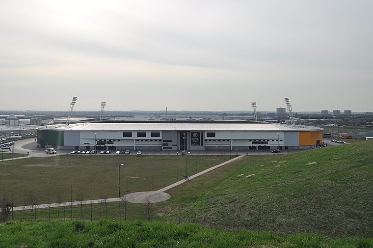 The Eco-Power Stadium is a multi-purpose stadium in Doncaster, England, with a capacity of 15,231. It cost approximately £20 million to construct, as part of the wider Lakeside Sports Complex that it resides within which in total cost approximately £32 million, and is used by Doncaster Rovers, Doncaster Rugby League Club and Doncaster Rovers Belles Ladies Football Club. Keepmoat Stadium is situated 1 mile west of Bawtry Road/The Avenue.
Doncaster Racecourse
Athletics track
Doncaster Racecourse is a racecourse in Doncaster, South Yorkshire, England. It hosts two of Great Britain's 36 annual Group 1 flat races, the St Leger Stakes and the Racing Post Trophy. Doncaster Racecourse is situated 3,000 feet north of Bawtry Road/The Avenue.
Places in the Area
Nearby places include Lakeside and Bessacarr.
Lakeside
Suburb
Lakeside is a suburb of Doncaster, South Yorkshire, England, centred around a circular lake. Approximately 2 miles south-east of central Doncaster, it has recently seen new development and modernisation with the construction of several new luxury housing…
Bessacarr
Suburb

Photo: Steve F, CC BY-SA 2.0.
Bessacarr is a suburb on the south-east edge of Doncaster, South Yorkshire, England. Consisting of mostly private residential development from the 1960s onward, it also contains some of the most expensive property in Doncaster, around St Wildfrid's Road and Warning Tongue Lane.
Belle Vue
Neighborhood
Belle Vue is an inner suburb of Doncaster, South Yorkshire, England. It was the location of the home ground of Doncaster Rovers F.C. and the Doncaster Lakers RLFC, until 2007 (when the new Keepmoat Stadium replaced it.
Bawtry Road/The Avenue
- Type: Bus stop
- Category: transportation
- Location: Doncaster, England, United Kingdom, Britain and Ireland, Europe
- View on OpenStreetMap
Latitude
53.51349° or 53° 30′ 49″ northLongitude
-1.09236° or 1° 5′ 33″ westOpen location code
9C5WGW75+93OpenStreetMap ID
node 502453626OpenStreetMap feature
highway=bus_stopOpenStreetMap feature
public_transport=platform
This page is based on OpenStreetMap, Wikidata, and Wikimedia Commons.
We’d love your help improving our open data sources. Thank you for contributing.
Satellite Map
Discover Bawtry Road/The Avenue from above in high-definition satellite imagery.
Notable Places Nearby
Highlights include Clancy Briggs Cycling Academy and The Salvation Army - Doncaster.
Nearby Places
Explore places such as Bawtry Road/St Augustines Road and Bessacarr Newsagents.
England: Must-Visit Destinations
Delve into London, Manchester, Sheffield, and Leeds.
Curious Bus Stops to Discover
Uncover intriguing bus stops from every corner of the globe.
About Mapcarta. Data © OpenStreetMap contributors and available under the Open Database License". Text is available under the CC BY-SA 4.0 license, except for photos, directions, and the map. Photo: sidibousaid, CC BY 2.0.