Balby Road/Bainbridge Road
Balby Road/Bainbridge Road is a bus stop in Doncaster, England. Balby Road/Bainbridge Road is situated nearby to St Francis Xavier Catholic Primary School, as well as near Westfield Park.| Tap on a place to explore it |
Places of Interest Nearby
Highlights include Doncaster railway station and Church of St James.
Doncaster railway station
Railway station

Photo: Christine Matthews, CC BY-SA 2.0.
Doncaster railway station is on the East Coast Main Line serving the city of Doncaster, South Yorkshire, England. It is 155 miles 77 chains down the line from London King's Cross and is situated between Retford and York on the main line. Doncaster railway station is situated 3,200 feet north of Balby Road/Bainbridge Road.
Church of St James
Church
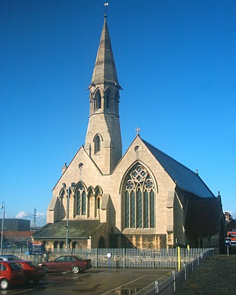
Photo: Captain Scarlet, CC BY 2.5.
Church of St James is situated 2,100 feet north of Balby Road/Bainbridge Road.
Keepmoat Stadium
Stadium
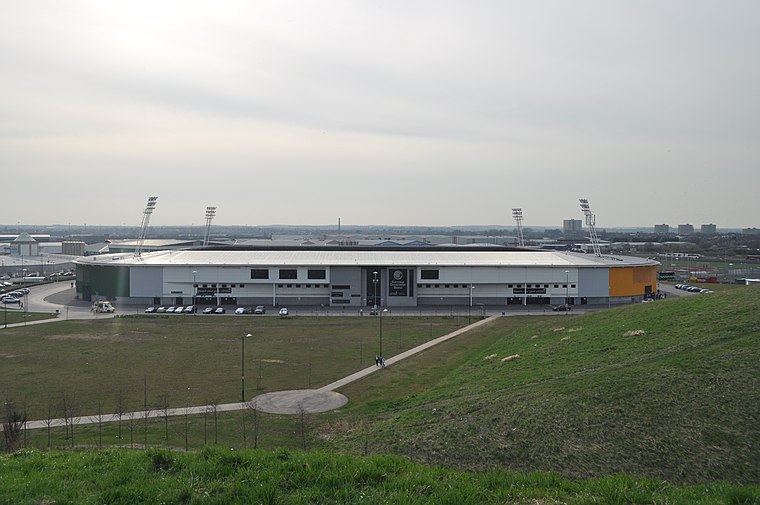 The Eco-Power Stadium is a multi-purpose stadium in Doncaster, England, with a capacity of 15,231. It cost approximately £20 million to construct, as part of the wider Lakeside Sports Complex that it resides within which in total cost approximately £32 million, and is used by Doncaster Rovers, Doncaster Rugby League Club and Doncaster Rovers Belles Ladies Football Club. Keepmoat Stadium is situated 1¼ miles east of Balby Road/Bainbridge Road.
Places in the Area
Nearby places include Hexthorpe and Doncaster.
Hexthorpe
Suburb

Photo: John Bayes, CC BY-SA 2.0.
Hexthorpe is a suburb of Doncaster, South Yorkshire, England. Historically part of the West Riding of Yorkshire, the area's shape resembles a rhombus, with borders with Balby and Doncaster city centre, separated by railway lines and the river separating the area from the villages of Sprotbrough and Newton.
Doncaster

Photo: Harleyamber, CC BY 3.0.
Doncaster is an industrial city in South Yorkshire in the north of England, with a population of about 110,000 in 2019. It's a metropolitan borough which also includes the towns of Bawtry, Mexborough, Conisbrough, Hatfield and Stainforth.
Balby
Suburb

Photo: Bill Henderson, CC BY-SA 2.0.
Balby is a suburb of Doncaster in South Yorkshire, England, located south-west of the city centre. Historically part of the West Riding of Yorkshire, Balby is within the Doncaster Central constituency and contains the electoral wards Balby South and Hexthorpe and Balby North.
Balby Road/Bainbridge Road
- Type: Bus stop
- Category: transportation
- Location: Doncaster, England, United Kingdom, Britain and Ireland, Europe
- View on OpenStreetMap
Latitude
53.51332° or 53° 30′ 48″ northLongitude
-1.14088° or 1° 8′ 27″ westOpen location code
9C5WGV75+8JOpenStreetMap ID
node 502458439OpenStreetMap feature
highway=bus_stopOpenStreetMap feature
public_transport=platform
This page is based on OpenStreetMap, Wikidata, and Wikimedia Commons.
We’d love your help improving our open data sources. Thank you for contributing.
Satellite Map
Discover Balby Road/Bainbridge Road from above in high-definition satellite imagery.
Notable Places Nearby
Highlights include St Francis Xavier Catholic Primary School and Westfield Park.
Nearby Places
Explore places such as Shell and Balby Road/Kelham Street.
England: Must-Visit Destinations
Delve into London, Manchester, Sheffield, and Leeds.
Curious Bus Stops to Discover
Uncover intriguing bus stops from every corner of the globe.
About Mapcarta. Data © OpenStreetMap contributors and available under the Open Database License". Text is available under the CC BY-SA 4.0 license, except for photos, directions, and the map. Photo: sidibousaid, CC BY 2.0.