Veggie Lounge
Veggie Lounge is a restaurant in Wolverhampton, England which is located on Dudley Road. Veggie Lounge is situated nearby to Black Country Millennium Forest, as well as near Lower Villers Street Park.| Tap on a place to explore it |
- Type: Restaurant
- Cuisine: international
- Address: 441 Dudley Road, Wolverhampton, WV2 3AQ
Places of Interest Nearby
Highlights include Molineux Stadium and St Luke’s Church, Blakenhall.
Molineux Stadium
Stadium
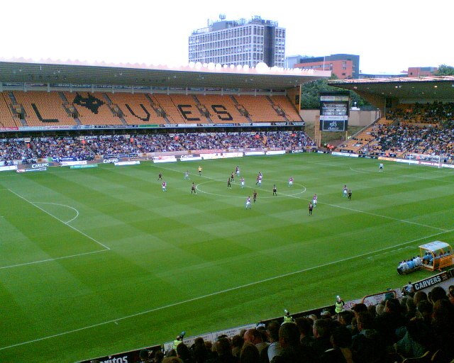
Photo: John Nickolls, CC BY-SA 2.0.
Molineux Stadium is a football stadium situated in Wolverhampton, West Midlands, England. It has been the home ground of Premier League club Wolverhampton Wanderers since 1889. Molineux Stadium is situated 1¼ miles north of Veggie Lounge.
St Luke’s Church, Blakenhall
Antique shop

Photo: Roger Kidd, CC BY-SA 2.0.
St Luke's Church, Blakenhall is a Grade II* listed former parish church in the Church of England in Blakenhall, Wolverhampton. St Luke’s Church, Blakenhall is situated 910 feet southwest of Veggie Lounge.
Wolverhampton Art Gallery
Museum
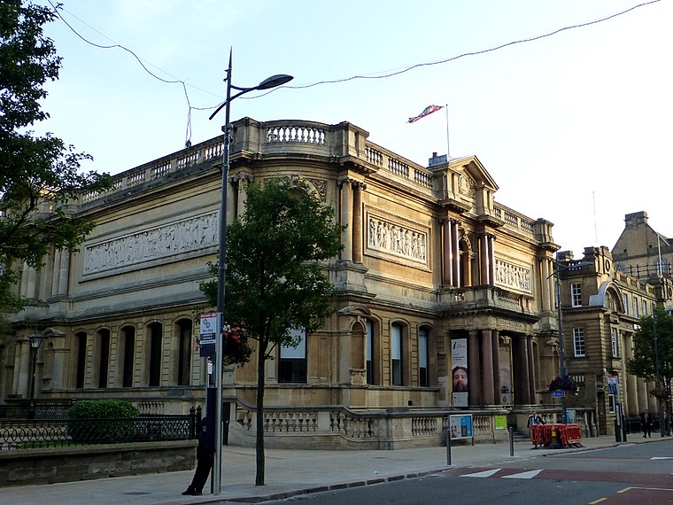
Photo: Æthelred, CC BY-SA 3.0.
Wolverhampton Art Gallery is located in Wolverhampton, England. The building was funded and constructed by local contractor Philip Horsman, and built on land provided by the municipal authority. It opened in May 1884. Wolverhampton Art Gallery is situated 1 mile north of Veggie Lounge.
Places in the Area
Nearby places include All Saints and Springfield.
All Saints
Quarter
All Saints is an inner city area of Wolverhampton, West Midlands, England. It is situated immediately to the south-east of the city centre, in the city council's Ettingshall ward.
Springfield
Quarter

Photo: John M, CC BY-SA 2.0.
Springfield is an area of Wolverhampton, England immediately north east of the city centre. It was the home of the Springfield Brewery from 1873 until 1991.
Bilston
Town

Photo: Roger Kidd, CC BY-SA 2.0.
Bilston is a market town in the City of Wolverhampton in the West Midlands, England. It is in the Black Country, 2.5 miles south east of Wolverhampton city centre and close to the borders of Sandwell and Walsall. Bilston is situated 2 miles east of Veggie Lounge.
Veggie Lounge
- Category: food
- Location: Wolverhampton, England, United Kingdom, Britain and Ireland, Europe
- View on OpenStreetMap
Latitude
52.57408° or 52° 34′ 27″ northLongitude
-2.12663° or 2° 7′ 36″ westOpen location code
9C4VHVFF+J8OpenStreetMap ID
node 5095567677OpenStreetMap feature
amenity=restaurantOpenStreetMap attribute
cuisine=international
This page is based on OpenStreetMap, Wikidata, and Wikimedia Commons.
We’d love your help improving our open data sources. Thank you for contributing.
Satellite Map
Discover Veggie Lounge from above in high-definition satellite imagery.
Notable Places Nearby
Highlights include Black Country Millennium Forest and Lower Villers Street Park.
Nearby Places
Explore places such as Dudley Rd / Mason St and Kings Arms.
England: Must-Visit Destinations
Delve into London, Manchester, Sheffield, and Leeds.
Curious Restaurants to Discover
Uncover intriguing restaurants from every corner of the globe.
About Mapcarta. Data © OpenStreetMap contributors and available under the Open Database License". Text is available under the CC BY-SA 4.0 license, except for photos, directions, and the map. Photo: Mariegriffiths, CC BY-SA 4.0.