Instituto Suyay
Instituto Suyay is a school in Comuna 6, Buenos Aires, Buenos Aires. Instituto Suyay is situated nearby to the pitch Caballito Norte, as well as near the police station Comisaría Comunal 6.| Tap on a place to explore it |
- Email: institutosuyay2007@yahoo.com.ar
- Type: School
- Address: Ciudad Autónoma de Buenos Aires, 1405
Places of Interest Nearby
Highlights include Estadio Arquitecto Ricardo Etcheverri and Museo de Esculturas Luis Perlotti.
Estadio Arquitecto Ricardo Etcheverri
Stadium
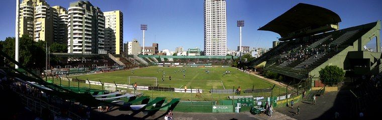
Photo: Facundo Diez, CC BY-SA 3.0.
Estadio Arquitecto Ricardo Etcheverri, formerly known as Estadio Ferro Carril Oeste, is a football stadium located in the Caballito district of Buenos Aires. Estadio Arquitecto Ricardo Etcheverri is situated 320 metres east of Instituto Suyay.
Museo de Esculturas Luis Perlotti
Museum

Photo: Perlotti, CC BY-SA 4.0.
Museo de Esculturas Luis Perlotti is a museum, which is situated 430 metres northeast of Instituto Suyay.
Caballito train station
Railway station

Photo: Banfield, CC BY-SA 2.5 ar.
Caballito train station is a railway station, which is situated 710 metres east of Instituto Suyay.
Places in the Area
Nearby places include Caballito and Parque Chacabuco.
Caballito
Suburb

Photo: OneEuropeanHeart, CC BY 4.0.
Caballito is a barrio of the Argentine capital, Buenos Aires. It is the only barrio in the administrative division Comuna 6. It is located in the geographical centre of the city, limited by the following streets and avenues: Rio de Janeiro, Av.
Parque Chacabuco
Suburb

Photo: Jorge Gobbi, CC BY 2.0.
Parque Chacabuco is a neighbourhood in Buenos Aires, Argentina. Its name is due to Chacabuco Park, which is in its centre, taking the name from the Battle of Chacabuco. Parque Chacabuco is situated 2½ km southeast of Instituto Suyay.
Casa Colectiva Parque Los Andes
Neighborhood

Photo: Roberto Fiadone, CC BY-SA 4.0.
Casa Colectiva Parque Los Andes is a neighborhood, which is situated 3 km north of Instituto Suyay.
Instituto Suyay
- Category: education
- Location: Comuna 6, Buenos Aires, Buenos Aires, Pampas, Argentina, South America
- View on OpenStreetMap
Latitude
-34.61819° or 34° 37′ 6″ southLongitude
-58.45133° or 58° 27′ 5″ westOpen location code
48Q39GJX+PFOpenStreetMap ID
node 5117499427OpenStreetMap feature
amenity=school
This page is based on OpenStreetMap, Wikidata, and Wikimedia Commons.
We’d love your help improving our open data sources. Thank you for contributing.
Satellite Map
Discover Instituto Suyay from above in high-definition satellite imagery.
Notable Places Nearby
Highlights include Caballito Norte and Comisaría Comunal 6.
Nearby Places
Explore places such as Aranguren y Oroño and Aranguren y Oroño.
Buenos Aires: Must-Visit Destinations
Delve into Centro, Palermo & Recoleta, La Boca & Barracas, and Outskirts.
Curious Schools to Discover
Uncover intriguing schools from every corner of the globe.
About Mapcarta. Data © OpenStreetMap contributors and available under the Open Database License". Text is available under the CC BY-SA 4.0 license, except for photos, directions, and the map. Photo: Moemoemoe, CC0.