Haldens Lumbards
Haldens Lumbards is a bus stop in Welwyn Hatfield, Hertfordshire, England. Haldens Lumbards is situated nearby to the church Kingdom Hall of Jehovah’s Witnesses, as well as near Revivall Church.| Tap on a place to explore it |
Places of Interest Nearby
Highlights include Welwyn North railway station and Welwyn Garden City railway station.
Welwyn North railway station
Railway station

Photo: Wikimedia, Copyrighted free use.
Welwyn North railway station serves the villages of Digswell and Welwyn in Hertfordshire, England. The station is located 22 miles north of London King's Cross, on the East Coast Main Line. Train services are currently provided by Great Northern. Welwyn North railway station is situated 1 mile north of Haldens Lumbards.
Welwyn Garden City railway station
Railway station
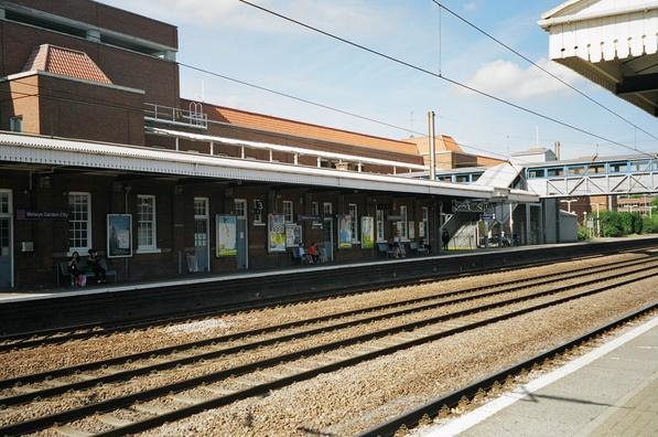
Photo: Wikimedia, Copyrighted free use.
Welwyn Garden City railway station serves the town of Welwyn Garden City in Hertfordshire, England. It is 20 miles 25 chains from London King's Cross on the East Coast Main Line. Train services are currently provided by Thameslink and Great Northern. Welwyn Garden City railway station is situated 1 mile southwest of Haldens Lumbards.
Digswell Viaduct
Bridge

Photo: Wikimedia, Copyrighted free use.
The Digswell Viaduct, also known as the Welwyn Viaduct and officially the Welwyn Railway Viaduct, is a railway viaduct that carries the two tracks of the East Coast Main Line over the Mimram Valley in Hertfordshire, East of England. Digswell Viaduct is situated 3,500 feet northwest of Haldens Lumbards.
Places in the Area
Nearby places include Digswell and Welwyn Garden City.
Digswell
Village

Photo: Robert Edwards, CC BY-SA 2.0.
Digswell is a village and former parish in the English county of Hertfordshire which is recorded in the 1086 Domesday Book. The population of the urban area of Digswell in the 2011 Census was 1,632.
Welwyn Garden City

Photo: Cmglee, CC BY-SA 4.0.
Welwyn Garden City is a town in Hertfordshire, England. It was the second "garden city" in England, and one of the first "new towns". It is unique in being both a garden city and a new town and exemplifies the physical, social and cultural planning ideals of the periods in which it was built.
Welwyn
Village

Photo: John Salmon, CC BY-SA 2.0.
Welwyn is a village and civil parish in Hertfordshire, England. The parish also includes the nearby villages and settlements of Digswell, Mardley Heath and Oaklands. Welwyn is situated 2 miles northwest of Haldens Lumbards.
Haldens Lumbards
- Type: Bus stop
- Category: transportation
- Location: Welwyn Hatfield, Hertfordshire, East of England, England, United Kingdom, Britain and Ireland, Europe
- View on OpenStreetMap
Latitude
51.81093° or 51° 48′ 39″ northLongitude
-0.18563° or 0° 11′ 8″ westOpen location code
9C3XRR67+9POpenStreetMap ID
node 5187306719OpenStreetMap feature
highway=bus_stopOpenStreetMap feature
public_transport=platform
This page is based on OpenStreetMap, Wikidata, and Wikimedia Commons.
We’d love your help improving our open data sources. Thank you for contributing.
Satellite Map
Discover Haldens Lumbards from above in high-definition satellite imagery.
Notable Places Nearby
Highlights include Kingdom Hall of Jehovah’s Witnesses and Revivall Church.
Nearby Places
Explore places such as Maple Grove Allotment Gardens and Rowans Allotment Gardens.
Hertfordshire: Must-Visit Destinations
Delve into St Albans, Watford, Stevenage, and Hertford.
Curious Bus Stops to Discover
Uncover intriguing bus stops from every corner of the globe.
About Mapcarta. Data © OpenStreetMap contributors and available under the Open Database License". Text is available under the CC BY-SA 4.0 license, except for photos, directions, and the map. Photo: Wikimedia, CC0.