Sanatorio Avenida
Sanatorio Avenida is a clinic in General Pueyrredón Partido, Buenos Aires which is located on Alvarado. Sanatorio Avenida is situated nearby to the police station DDI Mar del Plata, as well as near Comisaría Mar del Plata 2°.| Tap on a place to explore it |
Places of Interest Nearby
Highlights include Juan Carlos Castagnino Municipal Museum of Art and Casino Central.
Juan Carlos Castagnino Municipal Museum of Art
Museum
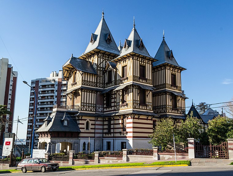
Photo: Edufortes, CC BY-SA 3.0.
The Juan Carlos Castagnino Municipal Museum of Art is a museum of fine arts in Mar del Plata, Argentina. Its building, the Ortiz Basualdo Villa, is a National Monument of Argentina. Juan Carlos Castagnino Municipal Museum of Art is situated 1 km east of Sanatorio Avenida.
Casino Central
Casino

Photo: Mar del Plata Puntonoticias, CC BY-SA 2.0.
The Casino Central is located in Mar del Plata, Argentina, and is one of the largest casinos in the country. Casino Central is situated 1¼ km north of Sanatorio Avenida.
Playa Bristol
Beach

Photo: Wikimedia, Public domain.
The Playa Bristol is a beach in Mar del Plata, Argentina, named after the Bristol Hotel. At one time it was highly fashionable, drawing the elite of Buenos Aires for vacations. Playa Bristol is situated 1¼ km northeast of Sanatorio Avenida.
Places in the Area
Nearby places include Mar del Plata.
Mar del Plata

Photo: DarwIn, CC BY-SA 3.0.
Mar del Plata is on the southwest coast of the Argentinian sea. It is the second most touristic city in the country after Buenos Aires. You can go to Mar del Plata by plane, by bus, by train or by car.
Sanatorio Avenida
- Type: Clinic
- Address: 1770 Alvarado, 7600
- Category: health care
- Location: General Pueyrredón Partido, Buenos Aires, Pampas, Argentina, South America
- View on OpenStreetMap
Latitude
-38.01413° or 38° 0′ 51″ southLongitude
-57.54743° or 57° 32′ 51″ westOpen location code
48H4XFP3+82OpenStreetMap ID
node 5273312821OpenStreetMap feature
amenity=clinicOpenStreetMap feature
healthcare=clinic
This page is based on OpenStreetMap, Wikidata, and Wikimedia Commons.
We’d love your help improving our open data sources. Thank you for contributing.
Satellite Map
Discover Sanatorio Avenida from above in high-definition satellite imagery.
Notable Places Nearby
Highlights include DDI Mar del Plata and Comisaría Mar del Plata 2°.
Nearby Places
Explore places such as 523 and Fede.
Buenos Aires: Must-Visit Destinations
Delve into Buenos Aires, La Plata, Mar del Plata, and Centro.
Curious Clinics to Discover
Uncover intriguing clinics from every corner of the globe.
About Mapcarta. Data © OpenStreetMap contributors and available under the Open Database License". Text is available under the CC BY-SA 4.0 license, except for photos, directions, and the map. Photo: Mbusin, CC BY-SA 4.0.