High Street/Lord Street (YA)
High Street/Lord Street (YA) is a bus stop in Oldham, England. High Street/Lord Street (YA) is situated nearby to the pub The Up Steps Inn, as well as near the monument Oldham War Memorial.| Tap on a place to explore it |
Places of Interest Nearby
Highlights include Oldham Parish Church and Oldham War Memorial.
Oldham Parish Church
Church

Photo: Rept0n1x, CC BY-SA 3.0.
The Church of St Mary with St Peter, commonly known as Oldham Parish Church, is the Church of England parish church of Oldham in Greater Manchester, England.
Oldham War Memorial
Monument
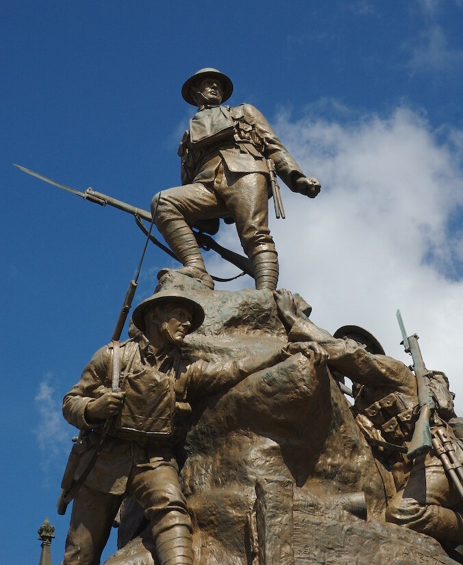
Photo: Narniauk, Public domain.
Oldham War Memorial is a war memorial in Oldham, Greater Manchester, England, comprising a large bronze sculpture group on a granite plinth. It was built to commemorate the men of Oldham who were killed in the First World War.

Places in the Area
Nearby places include Oldham and Coldhurst.
Oldham

Photo: Parrot of Doom, CC BY-SA 3.0.
Oldham is a former textile town in Greater Manchester, 7 miles northeast of city centre in the foothills of the Pennines. The main reason to visit is to explore the villages and valleys leading into the Pennines. In 2011 the population was over 96,000.
Coldhurst
Suburb
Coldhurst is an area of Oldham and an electoral ward of the wider Metropolitan Borough of Oldham in Greater Manchester, England. At the time of the United Kingdom Census 2001, it had a population of 11,935, increasing to 13,201 at the 2011 Census.
Glodwick
Suburb
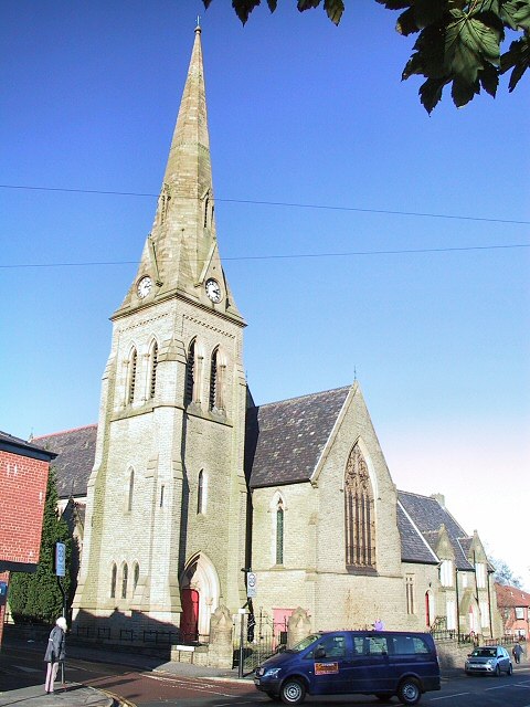
Photo: Wikimedia, CC BY-SA 2.0.
Glodwick is an area of Oldham, Greater Manchester, England. It is south-east of Oldham town centre. Glodwick is a multi-ethnic residential area in the south of Oldham, home particularly to a large community of Pakistanis and British Pakistanis.
High Street/Lord Street (YA)
- Type: Bus stop
- Category: transportation
- Location: Oldham, England, United Kingdom, Britain and Ireland, Europe
- View on OpenStreetMap
Latitude
53.54209° or 53° 32′ 32″ northLongitude
-2.11235° or 2° 6′ 45″ westNetwork
TfGMOpen location code
9C5VGVRQ+R3OpenStreetMap ID
node 533803706OpenStreetMap feature
highway=bus_stopOpenStreetMap feature
public_transport=platform
This page is based on OpenStreetMap, Wikidata, and Wikimedia Commons.
We’d love your help improving our open data sources. Thank you for contributing.
Satellite Map
Discover High Street/Lord Street (YA) from above in high-definition satellite imagery.
Notable Places Nearby
Highlights include ODEON Oldham and Spindles Town Square Shopping Centre.
Nearby Places
Explore places such as Oldham, High Street / Town Square (Stop YB) and Simpsons of Oldham Jewellers.
England: Must-Visit Destinations
Delve into London, Manchester, Sheffield, and Leeds.
Curious Bus Stops to Discover
Uncover intriguing bus stops from every corner of the globe.
About Mapcarta. Data © OpenStreetMap contributors and available under the Open Database License". Text is available under the CC BY-SA 4.0 license, except for photos, directions, and the map. Photo: sidibousaid, CC BY 2.0.