Drinkers World
Drinkers World is a liquor store in Stourport-on-Severn, Wyre Forest District, England. Drinkers World is situated nearby to the amusement arcade Flamingo Amusements, as well as near Rendezvous Amusements.| Tap on a place to explore it |
Places of Interest Nearby
Highlights include Church of St Bartholomew and Areley Hall.
Church of St Bartholomew
Church

Photo: Philip Pankhurst, CC BY-SA 2.0.
Church of St Bartholomew is situated 2,600 feet west of Drinkers World.
Areley Hall
House
Areley Hall is a Grade II listed country house near Areley Kings in Stourport-on-Severn, Worcestershire, England. It is not to be confused with nearby Astley Hall, the former home of Prime Minister Stanley Baldwin. Areley Hall is situated 1,700 feet west of Drinkers World.
Church of All Saints, Wilden
Church
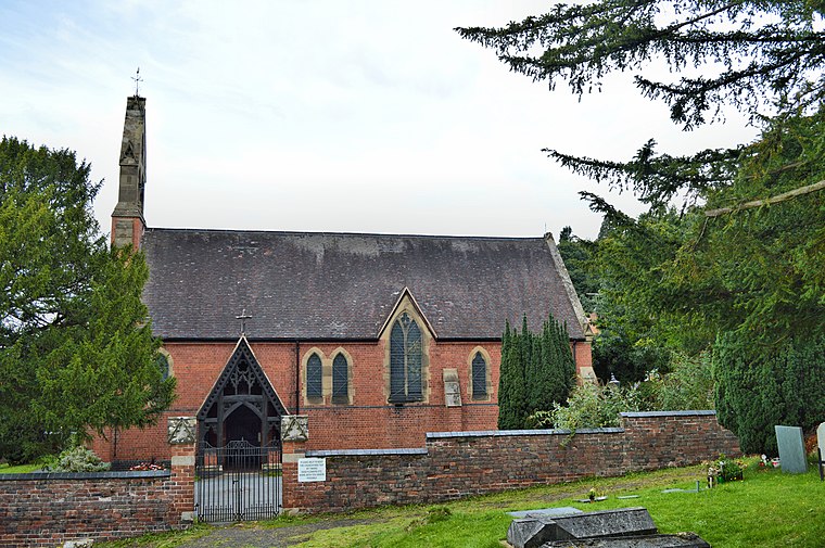
Photo: Philip Pankhurst, CC BY-SA 2.0.
All Saints Church in Wilden, Worcestershire about one mile to the north east of Stourport. It was designed by William Hopkins with funds provided by Alfred Baldwin very close to his own home, Wilden House and one of his large iron works. Church of All Saints, Wilden is situated 1 mile northeast of Drinkers World.
Places in the Area
Nearby places include Areley Kings and Wilden.
Areley Kings
Suburb
Photo: David Stowell, CC BY-SA 2.0.
Areley Kings is a village on the River Severn, in the civil parish of Stourport-on-Severn, in the Wyre Forest of Worcestershire, England. It is 10 miles north of Worcester and south of Stourport on Severn.
Wilden
Village

Photo: Martyn B, CC BY-SA 2.0.
Wilden is a small village about 1 mile north east of Stourport-on-Severn, Worcestershire. It is in the Stour valley and both the River Stour and the Staffordshire and Worcestershire Canal pass through the parish before joining the River Severn at Stourport.
Dunley
Village

Photo: Peter Whatley, CC BY-SA 2.0.
Dunley is a village, and a civil parish, in the administrative district of Malvern Hills in the county of Worcestershire, England. Dunley is situated 2 miles southwest of Drinkers World.
Drinkers World
- Type: Liquor store
- Category: shop
- Location: Stourport-on-Severn, Wyre Forest District, Worcestershire, West Midlands, England, United Kingdom, Britain and Ireland, Europe
- View on OpenStreetMap
Latitude
52.33897° or 52° 20′ 20″ northLongitude
-2.28095° or 2° 16′ 51″ westOpen location code
9C4V8PQ9+HJOpenStreetMap ID
node 5385152843OpenStreetMap feature
shop=alcohol
This page is based on OpenStreetMap, Wikidata, and Wikimedia Commons.
We’d love your help improving our open data sources. Thank you for contributing.
Satellite Map
Discover Drinkers World from above in high-definition satellite imagery.
Notable Places Nearby
Highlights include Flamingo Amusements and Rendezvous Amusements.
Nearby Places
Explore places such as The Co-operative Funeralcare and Open Kitchen Café.
Worcestershire: Must-Visit Destinations
Delve into Worcester, Redditch, Kidderminster, and Evesham.
Curious Liquor Stores to Discover
Uncover intriguing liquor stores from every corner of the globe.
About Mapcarta. Data © OpenStreetMap contributors and available under the Open Database License". Text is available under the CC BY-SA 4.0 license, except for photos, directions, and the map. Photo: Tanya Dedyukhina, CC BY 3.0.