Chalet Larchenheim
Chalet Larchenheim is a guest house in Zermatt, Visp District, Valais which is located on Schanze. Chalet Larchenheim is situated nearby to Zermatt Youth Hostel, as well as near Haus Andy Sauna.| Tap on a place to explore it |
Places of Interest Nearby
Highlights include Matterhorn Museum and St. Maurice church.
Matterhorn Museum
Museum
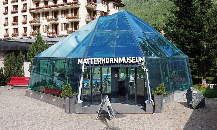
Photo: Kulmalukko, CC BY-SA 3.0.
The Matterhorn Museum is a cultural-natural museum in Zermatt whose main theme is the Matterhorn. The museum is in the form of a reconstituted mountain village consisting of 14 houses, and relates the history and development of tourism in the Zermatt area, including the story of the first ascent of the Matterhorn by Edward Whymper and party. Matterhorn Museum is situated 420 metres northwest of Chalet Larchenheim.
St. Maurice church
Church

Photo: Nbltsgndpfrdbrms, CC BY-SA 3.0.
St. Maurice church is situated 390 metres northwest of Chalet Larchenheim.
Chapel of the Holy Family
Church

Photo: Paebi, CC BY-SA 4.0.
Chapel of the Holy Family is a church, which is situated 460 metres southwest of Chalet Larchenheim.
Places in the Area
Nearby places include Findeln and Sunnegga.
Findeln
Locality

Photo: Zermatt photos, CC BY-SA 3.0.
Findeln is a group of hamlets above Zermatt in the canton of Valais. They are located on the south facing slopes of the Sunnegga–Unterrothorn–Oberrothorn mountains.

Riffelalp
Hamlet

Photo: Wikimedia, CC BY-SA 3.0.
Riffelalp is a hamlet in the municipality of Zermatt in the canton of Valais. It is located at a height of 2,222 metres above sea level, just above the tree line, approximately halfway between the town of Zermatt and the Gornergrat mountain.
Chalet Larchenheim
- Type: Guest house
- Address: Schanze 12, Zermatt, 3920
- Categories: tourism, accommodation, and building
- Location: Zermatt, Visp District, Valais, Switzerland, Central Europe, Europe
- View on OpenStreetMap
Latitude
46.01635° or 46° 0′ 59″ northLongitude
7.74885° or 7° 44′ 56″ eastOpen location code
8FR92P8X+GGOpenStreetMap ID
node 5464793589OpenStreetMap feature
tourism=guest_house
This page is based on OpenStreetMap, Wikidata, and Wikimedia Commons.
We’d love your help improving our open data sources. Thank you for contributing.
Satellite Map
Discover Chalet Larchenheim from above in high-definition satellite imagery.
Notable Places Nearby
Highlights include Zermatt Youth Hostel and Haus Andy Sauna.
Nearby Places
Explore places such as Chalet Aria and Albatros Zermat.
Curious Guest Houses to Discover
Uncover intriguing guest houses from every corner of the globe.
About Mapcarta. Data © OpenStreetMap contributors and available under the Open Database License". Text is available under the CC BY-SA 4.0 license, except for photos, directions, and the map. Photo: Paul Asman and Jill Lenoble, CC BY 2.0.