Bailiff’s Point
Bailiff’s Point is a cape in Burghfield, West Berkshire, England.| Tap on a place to explore it |
Places of Interest
Highlights include Madejski Stadium and Reading Railway Station.
Madejski Stadium
Stadium

Photo: TheSportsDB, CC0.
The Madejski Stadium, currently known as the Select Car Leasing Stadium for sponsorship reasons, is a football stadium in Reading, Berkshire, England. It is the home of Reading Football Club, who play in EFL League One.
Reading Railway Station
Railway station
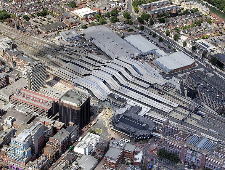
Photo: John Fielding, CC BY 2.0.
Reading railway station is a major transport hub in the town of Reading in Berkshire, England, it is 36 miles west of London Paddington. It is sited on the northern edge of the town centre, near to the main retail and commercial areas and the River Thames.
Reading Abbey

Photo: Chris j wood, CC BY-SA 4.0.
Reading Abbey is a large, ruined abbey in the centre of the town of Reading, in the English county of Berkshire. It was founded by Henry I in 1121 "for the salvation of my soul, and the souls of King William, my father, and of King William, my brother, and Queen Maud, my wife, and all my ancestors and successors." In its heyday the abbey was one of Europe's largest royal monasteries.
Places in the Area
Nearby places include Reading and Lower Earley.
Reading

Photo: Wikimedia, CC BY-SA 2.0.
Reading is a large, historic town in Berkshire in the South East of England. It is one of the largest towns without city status in the United Kingdom with just under 235,000 inhabitants.
Lower Earley
Suburb

Photo: Rosalind Mitchell, CC BY-SA 2.0.
Lower Earley is a suburb of Earley, a town in Berkshire, England. Lower Earley is a predominantly lower-density residential area lying on the northern banks of the River Loddon.
Caversham
Suburb

Photo: Jystyn, Public domain.
Reading is a large, historic town in Berkshire in the South East of England. It is one of the largest towns without city status in the United Kingdom with just under 235,000 inhabitants.
Bailiff’s Point
- Type: Cape
- Category: landform
- Location: Burghfield, West Berkshire, England, United Kingdom, Britain and Ireland, Europe
- View on OpenStreetMap
Latitude
51.4317° or 51° 25′ 54″ northLongitude
-1.0095° or 1° 0′ 34″ westOpen location code
9C3WCXJR+M6OpenStreetMap ID
node 5501863144OpenStreetMap feature
natural=cape
This page is based on OpenStreetMap, Wikidata, and Wikimedia Commons.
We’d love your help improving our open data sources. Thank you for contributing.
Satellite Map
Discover Bailiff’s Point from above in high-definition satellite imagery.
Localities in the Area
Explore places such as Burghfield Farm and Southcote.
Notable Places Nearby
Highlights include Hodder’s Island and Blue Pool.
England: Must-Visit Destinations
Delve into London, Manchester, Sheffield, and Leeds.
Curious Capes to Discover
Uncover intriguing capes from every corner of the globe.
About Mapcarta. Data © OpenStreetMap contributors and available under the Open Database License". Text is available under the CC BY-SA 4.0 license, except for photos, directions, and the map. Photo: sidibousaid, CC BY 2.0.