Durham Community Support Centre
Durham Community Support Centre is an office in County Durham, North East England, England which is located on Ainsley Street. Durham Community Support Centre is situated nearby to the community center Durham Miners’ Hall, as well as near Waddington Street United Reformed Church.| Tap on a place to explore it |
- Email: durhamcsc@gmail.com
- Type: Voluntary association
- Address: Ainsley Street, Durham, DH1 4BE
Places of Interest Nearby
Highlights include Durham Miners’ Hall and Maiden’s Bower.
Durham Miners’ Hall
Community center
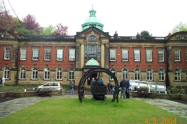
Photo: derek dye, CC BY-SA 2.0.
Redhills is Grade II listed headquarters building of the Durham Miners' Association in Durham, England. Officially called Miners' New Hall, it is known as Redhills from its location on Redhills Lane in the City of Durham.
Maiden’s Bower
Archaeological site

Photo: Aquaquaticat, CC BY 4.0.
Maiden's Bower is a Bronze Age round cairn built in Flass Vale Nature Reserve, in Durham, England. It is a scheduled monument with a list entry number of 1008843. Maiden’s Bower is situated 820 feet northwest of Durham Community Support Centre.
Durham railway station
Railway station

Photo: John Illingworth, CC BY-SA 2.0.
Durham is a railway station on the East Coast Main Line, which runs between London King's Cross and Edinburgh Waverley; it is situated 14 miles 3 chains south of Newcastle. Durham railway station is situated 1,500 feet northeast of Durham Community Support Centre.
Places in the Area
Nearby places include Crossgate and Neville’s Cross.
Crossgate
Suburb
Crossgate is a small area of housing that sits above North Road but below the Neville's Cross area of Durham, in County Durham, England. It is predominantly occupied by students at Durham University who favour the area due to its proximity to the university departments in the Elvet and Palace Green areas of the city.
Neville’s Cross
Suburb
Neville's Cross is a place in the civil parish of the City of Durham, in County Durham, England. It is also a ward of Durham with a population taken at the 2011 census of 9,940.
Durham
 Durham is a city in County Durham in North East England. The name is believed to derive from "Dun-holme", or hill-island, due to its location on a meander on the River Wear.
Durham Community Support Centre
- Category: office
- Location: County Durham, North East England, England, United Kingdom, Britain and Ireland, Europe
- View on OpenStreetMap
Latitude
54.77737° or 54° 46′ 39″ northLongitude
-1.5873° or 1° 35′ 14″ westOpen location code
9C6WQCG7+W3OpenStreetMap ID
node 5587487799OpenStreetMap feature
office=association
This page is based on OpenStreetMap, Wikidata, and Wikimedia Commons.
We’d love your help improving our open data sources. Thank you for contributing.
Satellite Map
Discover Durham Community Support Centre from above in high-definition satellite imagery.
Notable Places Nearby
Highlights include Waddington Street United Reformed Church and Durham City Spiritualist Church.
Nearby Places
Explore places such as John Forman and W. H. Patterson.
County Durham: Must-Visit Destinations
Delve into Durham, Darlington, Hartlepool, and Stockton-on-Tees.
Curious Places to Discover
Uncover intriguing places from every corner of the globe.
About Mapcarta. Data © OpenStreetMap contributors and available under the Open Database License". Text is available under the CC BY-SA 4.0 license, except for photos, directions, and the map. Photo: Roberto Strauss, CC BY 2.0.