Altwood School
Altwood School is a bus stop in Windsor and Maidenhead, England. Altwood School is situated nearby to St Edmund Campion Catholic Primary School, as well as near Altwood Church of England School.| Tap on a place to explore it |
Places of Interest Nearby
Highlights include Altwood Church of England School and Norden Farm Centre for the Arts.
Altwood Church of England School
School
Altwood Church of England School is the only Church of England secondary school in Maidenhead. Altwood School is an academy. The school draws pupils from across Maidenhead, Berkshire and Buckinghamshire. Altwood Church of England School is situated 830 feet northeast of Altwood School.
Norden Farm Centre for the Arts
Theater building
Norden Farm Centre for the Arts is a multi form arts centre located in Maidenhead, Berkshire, England providing a 225-seat theatre and 100-seat studio space. Norden Farm Centre for the Arts is situated 1,800 feet east of Altwood School.
Newlands Girls’ School
School

Photo: Rho9998, CC BY-SA 3.0.
Newlands Girls' School is a girls' secondary school and sixth form located in Maidenhead, Berkshire, England. Newlands Girls’ School is situated 2,400 feet northwest of Altwood School.
Places in the Area
Nearby places include Pinkneys Green and Stubbings.
Pinkneys Green
Hamlet

Photo: Des Blenkinsopp, CC BY-SA 2.0.
Pinkneys Green is a semi-rural village near the town of Maidenhead, Berkshire. It sits within the ancient parish of Cookham.
Stubbings
Hamlet

Photo: Michael FORD, CC BY-SA 2.0.
Stubbings is a hamlet in the civil parish of Bisham, west of Maidenhead, in the English county of Berkshire.
Maidenhead
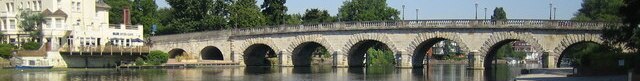
Photo: Nigel Cox, CC BY-SA 2.0.
Maidenhead is a large riverside town in the county of Berkshire in the South East of England. Like many towns, Maidenhead has lost some of its historic charm, and the town centre is a little uninspiring and overdeveloped in some parts.
Altwood School
- Type: Bus stop
- Also known as: “Lees Gardens” and “St Edmund Campion School”
- Category: transportation
- Location: Windsor and Maidenhead, England, United Kingdom, Britain and Ireland, Europe
- View on OpenStreetMap
Latitude
51.51576° or 51° 30′ 57″ northLongitude
-0.7541° or 0° 45′ 15″ westOpen location code
9C3XG68W+89OpenStreetMap ID
node 565771697OpenStreetMap feature
highway=bus_stop
This page is based on OpenStreetMap, Wikidata, and Wikimedia Commons.
We’d love your help improving our open data sources. Thank you for contributing.
Satellite Map
Discover Altwood School from above in high-definition satellite imagery.
Notable Places Nearby
Highlights include St Edmund Campion and St Edmund Campion Catholic Primary School.
Nearby Places
Explore places such as Altwood School and The New Hall.
England: Must-Visit Destinations
Delve into London, Manchester, Sheffield, and Leeds.
Curious Bus Stops to Discover
Uncover intriguing bus stops from every corner of the globe.
About Mapcarta. Data © OpenStreetMap contributors and available under the Open Database License". Text is available under the CC BY-SA 4.0 license, except for photos, directions, and the map. Photo: sidibousaid, CC BY 2.0.