Altogether Care
Altogether Care is a social service facility in Bath and North East Somerset, England which is located on London Road. Altogether Care is situated nearby to Saint Saviour’s Church, as well as near the recreation area Kensington Meadows.| Tap on a place to explore it |
Places of Interest Nearby
Highlights include Rondo Theatre and Cleveland Pools.
Rondo Theatre
Theater building

Photo: Jaggery, CC BY-SA 2.0.
The Rondo Theatre is a performing arts theatre in Bath, England that was established in 1989. The theatre is located in the former church hall of St Saviour's Church, Larkhall. Rondo Theatre is situated 1,100 feet north of Altogether Care.
Cleveland Pools
Recreation area

Photo: Rwendland, CC BY-SA 3.0.
Cleveland Pools located in Hampton Row, Bath, Somerset, England is a semi-circular lido built to designs by John Pinch the Elder in 1815. It is believed to be the oldest public outdoor swimming pool in the UK. Cleveland Pools is situated 1,200 feet south of Altogether Care.
Roman Baths
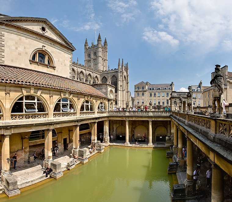 The Roman Baths are well-preserved thermae in the city of Bath, Somerset, England. A temple was constructed on the site between 60 and 70 AD in the first few decades of Roman Britain. Roman Baths is situated 1 mile southwest of Altogether Care.
Places in the Area
Nearby places include Larkhall and Walcot.
Larkhall
Suburb

Photo: Jonathan Billinger, CC BY-SA 2.0.
Larkhall is a residential district in the city of Bath, England, north-east of the city centre. The district began to develop in the early 19th century to house the working population of the city.
Walcot
Suburb
Photo: Maurice Pullin, CC BY-SA 2.0.
Walcot is a suburb of the city of Bath, in the Bath and North East Somerset district, in the ceremonial county of Somerset, England. It lies to the north-north-east of the city centre, and is an electoral ward of the city.
Bathwick
Suburb
Bathwick is an area and electoral ward in the city of Bath, in the Bath and North East Somerset district, in the ceremonial county of Somerset, England, on the opposite bank of the River Avon to the historic city centre.
Altogether Care
- Type: Social service facility
- Address: 5 London Road, BA1 6QA
- Location: Bath and North East Somerset, England, United Kingdom, Britain and Ireland, Europe
- View on OpenStreetMap
Latitude
51.39408° or 51° 23′ 39″ northLongitude
-2.34703° or 2° 20′ 49″ westOpen location code
9C3V9MV3+J5OpenStreetMap ID
node 5906221153OpenStreetMap feature
amenity=social_facility
This page is based on OpenStreetMap, Wikidata, and Wikimedia Commons.
We’d love your help improving our open data sources. Thank you for contributing.
Satellite Map
Discover Altogether Care from above in high-definition satellite imagery.
Notable Places Nearby
Highlights include Saint Saviour’s Church and Kensington Meadows.
Nearby Places
Explore places such as Hunter French and Bath Express Grocery And Off Licence.
England: Must-Visit Destinations
Delve into London, Manchester, Sheffield, and Leeds.
Curious Social Service Facilities to Discover
Uncover intriguing social service facilities from every corner of the globe.
About Mapcarta. Data © OpenStreetMap contributors and available under the Open Database License". Text is available under the CC BY-SA 4.0 license, except for photos, directions, and the map. Photo: sidibousaid, CC BY 2.0.