Twickenham Primary Academy
Twickenham Primary Academy is a school in England, United Kingdom which is located on Colne Road. Twickenham Primary Academy is situated nearby to Twickenham Green Baptist Church, as well as near the church Holy Trinity Twickenham.| Tap on a place to explore it |
- Type: School
- Description: school in Richmond upon Thames, UK
- Address: 57 Colne Road, Twickenham, TW2 6QF
Places of Interest Nearby
Highlights include Twickenham Stadium and Salvation Army.
Twickenham Stadium
Stadium
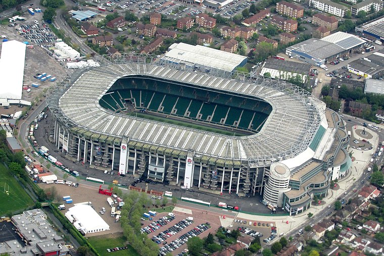
Photo: brewbooks, CC BY-SA 2.0.
Twickenham Stadium is a rugby union stadium in Twickenham, London, England. It is owned by the Rugby Football Union, the English rugby union governing body, which has its headquarters there. Twickenham Stadium is situated 4,000 feet north of Twickenham Primary Academy.
Salvation Army
Church
The Salvation Army, Twickenham is a Salvation Army church on May Road, Twickenham TW2 6QW in the London Borough of Richmond upon Thames. Its facilities include a community centre, part-funded by a housing association, Thames Valley Housing; the centre opened in 2014. Salvation Army is situated 790 feet west of Twickenham Primary Academy.
Holy Trinity Twickenham
Church

Photo: Jim Linwood, CC BY 2.0.
Holy Trinity Twickenham is a Grade II listed Church of England church on Twickenham Green in Twickenham in the London Borough of Richmond upon Thames, originally built to relieve pressure on the parish church of St Mary following a campaign backed by MP Sir William Clay. Holy Trinity Twickenham is situated 760 feet southwest of Twickenham Primary Academy.
Places in the Area
Nearby places include Strawberry Hill and Twickenham.
Strawberry Hill
Suburb

Photo: Colin Smith, CC BY-SA 2.0.
Strawberry Hill is an area of the London Borough of Richmond upon Thames in Twickenham. It is a suburban development situated 10.4 miles west south-west of Charing Cross.
Twickenham
Town
 Twickenham is a suburban district of London, England, on the River Thames 9.9 miles southwest of Charing Cross. Historically in Middlesex, since 1965 it has formed part of the London Borough of Richmond upon Thames, whose administrative headquarters are in the area.
Whitton
Suburb

Photo: David Hawgood, CC BY-SA 2.0.
Whitton is an area of the London Borough of Richmond upon Thames, England. Historically, it was the north-western part of Twickenham manor, bounded by the River Crane and the Duke of Northumberland's River.
Twickenham Primary Academy
- Categories: free school, primary school, and education
- Location: England, United Kingdom, Britain and Ireland, Europe
- View on OpenStreetMap
Latitude
51.4451° or 51° 26′ 42″ northLongitude
-0.33973° or 0° 20′ 23″ westOperator
Omnia Learning TrustOpen location code
9C3XCMW6+24OpenStreetMap ID
node 5906469054OpenStreetMap feature
amenity=schoolWikidata ID
Q66231126
This page is based on OpenStreetMap, Wikidata, and Wikimedia Commons.
We’d love your help improving our open data sources. Thank you for contributing.
Satellite Map
Discover Twickenham Primary Academy from above in high-definition satellite imagery.
Notable Places Nearby
Highlights include Twickenham Green Baptist Church and Zero Gravity Pilates.
Nearby Places
Explore places such as Heathgate House and Twickenham Green Cars.
England: Must-Visit Destinations
Delve into London, Manchester, Sheffield, and Leeds.
Curious Schools to Discover
Uncover intriguing schools from every corner of the globe.
About Mapcarta. Data © OpenStreetMap contributors and available under the Open Database License". Text is available under the CC BY-SA 4.0 license, except for photos, directions, and the map. Photo: sidibousaid, CC BY 2.0.