Left Turn
Left Turn is in Camarines Sur, Bicol. Left Turn is situated nearby to San Jose Chapel, as well as near United Church of Christ in the Philippines.| Tap on a place to explore it |
Places of Interest Nearby
Highlights include Naga Cathedral and Peñafrancia Basilica.
Naga Cathedral
Church

Photo: Dilindin, CC BY-SA 4.0.
The Metropolitan Cathedral and Parish of Saint John the Evangelist, also known as the Naga Metropolitan Cathedral, is a Roman Catholic cathedral in Naga, Camarines Sur, Philippines. Naga Cathedral is situated 600 metres west of Left Turn.
Peñafrancia Basilica
Church

Photo: Ralffralff, CC BY-SA 4.0.
The Minor Basilica and National Shrine of Our Lady of Peñafrancia, commonly known as the Peñafrancia Basilica, is a Roman Catholic minor basilica located on the outskirts of Naga City—also known as the Pilgrim City and Queen City of Bicol—in the Bicol Region of the Philippines. Peñafrancia Basilica is situated 1 km east of Left Turn.
Plaza Quince Martires
Park

Photo: IJVelas, CC BY-SA 3.0.
Plaza Quince Martires is a park, which is situated 1 km southwest of Left Turn.
Places in the Area
Nearby places include Naga and Canaman.
Naga

Photo: Ringer, CC BY-SA 4.0.
Naga is one of the largest and most important cities in the Bicol region, being its center of almost everything. It is the center of commerce in the province of Camarines Sur, and is the core of the organized Metro Naga.
Canaman
Town

Photo: Ringer, CC BY-SA 3.0.
Canaman, officially the Municipality of Canaman, is a municipality in the province of Camarines Sur, Philippines. According to the 2020 census, it has a population of 36,205 people. Canaman is situated 3 km northwest of Left Turn.
Camaligan
Town
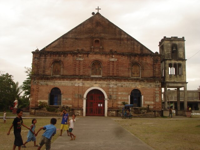
Photo: Ringer, CC BY-SA 3.0.
Camaligan, officially the Municipality of Camaligan, is a municipality in the province of Camarines Sur, Philippines. According to the 2020 census, it has a population of 25,036 people. Camaligan is situated 3½ km west of Left Turn.
Left Turn
- Type: Sign
- Categories: information and tourism
- Location: Camarines Sur, Bicol, Luzon, Philippines, Southeast Asia, Asia
- View on OpenStreetMap
Latitude
13.62937° or 13° 37′ 46″ northLongitude
123.19283° or 123° 11′ 34″ eastOpen location code
7Q55J5HV+P4OpenStreetMap ID
node 5907281639OpenStreetMap feature
tourism=information
This page is based on OpenStreetMap, Wikidata, and Wikimedia Commons.
We’d love your help improving our open data sources. Thank you for contributing.
Satellite Map
Discover Left Turn from above in high-definition satellite imagery.
Places with the Same Name
Discover other places named “Left Turn”.
Notable Places Nearby
Highlights include San Jose Chapel and United Church of Christ in the Philippines.
Nearby Places
Explore places such as Slow Down and Right Turn.
Camarines Sur: Must-Visit Destinations
Delve into Naga, Iriga, Pili, and Calabanga.
Curious Places to Discover
Uncover intriguing places from every corner of the globe.
About Mapcarta. Data © OpenStreetMap contributors and available under the Open Database License". Text is available under the CC BY-SA 4.0 license, except for photos, directions, and the map. Photo: Wikimedia, CC0.