College of Alameda Aviation Maintenance Facility
College of Alameda Aviation Maintenance Facility is a college in Alameda, California. College of Alameda Aviation Maintenance Facility is situated nearby to the recreation area Otis Spunkmeyer Field, as well as near the pitch Bill Osborne Model Airplane Field.| Tap on a place to explore it |
Places of Interest Nearby
Highlights include Arrowhead Marsh and Oakland Aviation Museum.
Arrowhead Marsh

Photo: Ingrid Taylar, CC BY 2.0.
Arrowhead Marsh is a wetlands habitat made of tidal mud flats in Martin Luther King, Jr. Shoreline in Oakland, California. It is an important stop on the Pacific flyway and is habitat for important endangered species especially the Salt Marsh Harvest Mouse.
Oakland Aviation Museum
Museum

Photo: Bill Larkins, CC BY-SA 2.0.
Oakland Aviation Museum, formerly called Western Aerospace Museum, in an aviation museum located at North Field of Oakland San Francisco Bay Airport in Oakland, California. Oakland Aviation Museum is situated 1 mile southeast of College of Alameda Aviation Maintenance Facility.
Bay Farm Island Bridge
Bridge

Photo: Dcoetzee, Public domain.
The San Leandro Bay Bridge, better known as the Bay Farm Island Bridge, is a single-leaf bascule drawbridge spanning the San Leandro Channel, the inlet of San Leandro Bay within the San Francisco Bay Area, California, United States. Bay Farm Island Bridge is situated 4,000 feet northwest of College of Alameda Aviation Maintenance Facility.
Places in the Area
Nearby places include Bay Farm Island and Fernside.
Bay Farm Island
Neighborhood
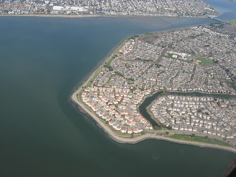
Photo: Dcoetzee, Public domain.
Bay Farm Island is a district of the city of Alameda, California, though it is separated from the rest of the city on Alameda Island by an estuary of San Leandro Bay.
Fernside
Neighborhood
Fernside is a neighborhood of Alameda in Alameda County, California. It lies at an elevation of 13 feet. Located near the Fruitvale and High Street bridges, it previously contained one train line which passed over the Fruitvale Bridge and another which followed the perimeter of Alameda's South Shore. Fernside is situated 1½ miles north of College of Alameda Aviation Maintenance Facility.
Alameda

Photo: Thatotherperson, CC BY-SA 3.0.
Alameda is an island city in the East Bay of the Bay Area, California. It is separated from the mainland by the Oakland Estuary. You can get there from Oakland very easily, by way of one of the bridges or the Webster Street Tube.
College of Alameda Aviation Maintenance Facility
- Type: College
- Category: education
- Location: Alameda, California, United States, North America
- View on OpenStreetMap
Latitude
37.74142° or 37° 44′ 29″ northLongitude
-122.22591° or 122° 13′ 33″ westOpen location code
849VPQRF+HJOpenStreetMap ID
node 6241187786OpenStreetMap feature
amenity=college
This page is based on OpenStreetMap, Wikidata, and Wikimedia Commons.
We’d love your help improving our open data sources. Thank you for contributing.
Satellite Map
Discover College of Alameda Aviation Maintenance Facility from above in high-definition satellite imagery.
Notable Places Nearby
Highlights include Otis Spunkmeyer Field and Bill Osborne Model Airplane Field.
Nearby Places
Explore places such as Oakland Radiosonde Station and A Plus Tree.
California: Must-Visit Destinations
Delve into San Francisco, Los Angeles, San Diego, and Sacramento.
Curious Places to Discover
Uncover intriguing places from every corner of the globe.
About Mapcarta. Data © OpenStreetMap contributors and available under the Open Database License". Text is available under the CC BY-SA 4.0 license, except for photos, directions, and the map. Photo: Miskatonic, CC BY 2.5.