Érable de Tournefort
Érable de Tournefort is a historic site in Paris, Île-de-France. Érable de Tournefort is situated nearby to the bandstand Buffon Gazebo, as well as near the scenic viewpoint Butte de Coupeaux.| Tap on a place to explore it |
Places of Interest Nearby
Highlights include Grand Mosque of Paris and Herbarium.
Grand Mosque of Paris
Mosque

Photo: LPLT, CC BY-SA 4.0.
The Grand Mosque of Paris, also known as the Great Mosque of Paris or simply the Paris Mosque, located in the 5th arrondissement of Paris, is one of the largest mosques in France. Grand Mosque of Paris is situated 110 metres southwest of Érable de Tournefort.
Herbarium
Museum

Photo: DIST Lyon1, CC BY-SA 4.0.
A herbarium is a collection of preserved plant specimens and associated data used for scientific study. The specimens may be whole plants or plant parts; these will usually be in dried form mounted on a sheet of paper but, depending upon the material, may also be stored in boxes or kept in alcohol or other preservative. Herbarium is situated 320 metres east of Érable de Tournefort.
Botanical Garden
Park
 The Jardin des Plantes, also known as the Jardin des Plantes de Paris when distinguished from other jardins des plantes in other cities, is the main botanical garden in France.
Places in the Area
Nearby places include 5th arrondissement and Latin Quarter.
5th arrondissement
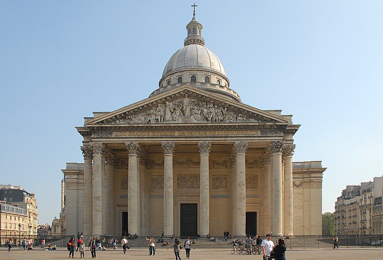
Photo: K’m, CC BY-SA 3.0.
The 5th Arrondissement of Paris is one of the best known of the city's central districts, located on the Left Bank of the river Seine. Also commonly known as the "Latin Quarter" because the first great Parisian university, the Sorbonne, was founded here and Latin was the language the medieval period students used once to speak.
Latin Quarter
Suburb

Photo: David.Monniaux, CC BY-SA 3.0.
The Latin Quarter of Paris is a district in Paris on the left bank of the Seine, around the Sorbonne. Located in the city's 5th and the 6th arrondissements, it is known for its concentration of universities.

Érable de Tournefort
- Type: Historic site
- Categories: tourist attraction and tourism
- Location: Paris, Île-de-France, France, Europe
- View on OpenStreetMap
Latitude
48.84295° or 48° 50′ 35″ northLongitude
2.35585° or 2° 21′ 21″ eastInception
1702Open location code
8FW4R9V4+58OpenStreetMap ID
node 6516343397OpenStreetMap feature
historic=treeOpenStreetMap feature
natural=tree
This page is based on OpenStreetMap, Wikidata, and Wikimedia Commons.
We’d love your help improving our open data sources. Thank you for contributing.
Satellite Map
Discover Érable de Tournefort from above in high-definition satellite imagery.
Notable Places Nearby
Highlights include Buffon Gazebo and Butte de Coupeaux.
Nearby Places
Explore places such as Daubenton and Théodore Monod.
Paris: Must-Visit Destinations
Delve into La Défense, 1st arrondissement, 7th arrondissement, and 8th arrondissement.
Curious Historic Sites to Discover
Uncover intriguing historic sites from every corner of the globe.
About Mapcarta. Data © OpenStreetMap contributors and available under the Open Database License". Text is available under the CC BY-SA 4.0 license, except for photos, directions, and the map. Photo: Benh, CC BY-SA 4.0.