Merle Stone Chevrolet
Merle Stone Chevrolet is a car dealership in Tulare County, San Joaquin Valley, California. Merle Stone Chevrolet is situated nearby to Trinity Lutheran Church, as well as near First Church of the Nazarene.| Tap on a place to explore it |
Places of Interest Nearby
Highlights include Sierra View Medical Center and Monache High School.
Sierra View Medical Center
Hospital
Sierra View Medical Center is a 167-bed, full-service acute care hospital located in Porterville, California. Founded in 1958, the hospital serves the Southern Sequoia region of California's Central Valley. Sierra View Medical Center is situated 1 mile southeast of Merle Stone Chevrolet.
Monache High School
School
Monache High School is one of the three high schools located in Porterville, California, United States and is part of the Porterville Unified School District. It's the city's second high school and as of 2021 serves approximately 2,583 students. Monache High School is situated 4,200 feet west of Merle Stone Chevrolet.
First Congregational Church
Church
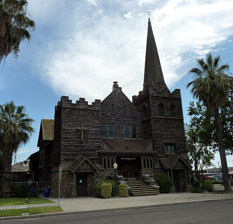 First Congregational Church is a historic church building at 165 East Mill Street in Porterville, California. The church was built in 1908 by Porterville's Congregationalists. San Francisco architects Francis W. First Congregational Church is situated 1½ miles southeast of Merle Stone Chevrolet.
Places in the Area
Nearby places include Porterville and Zante.
Porterville

Photo: Ragnar1470, CC BY-SA 4.0.
Porterville is a city at the base of Southern Sierra Nevada mountains on the eastern side of San Joaquin Valley, in Tulare County, California, United States.
Zante
Locality
Zante is an unincorporated community in the San Joaquin Valley, within Tulare County, central California. Zante is 3.5 miles north-northwest of Porterville. The town is named for the Zante currant, a type of small raisin and a crop grown in the area. Zante is situated 2½ miles north of Merle Stone Chevrolet.
Strathmore
Village
Strathmore is a census-designated place in Tulare County, California, United States. The population was 2,830 at the 2020 census, up from 2,819 at the 2010 census. Strathmore is situated 4½ miles north of Merle Stone Chevrolet.
Merle Stone Chevrolet
- Type: Car dealership
- Categories: shop and transportation
- Location: Tulare County, San Joaquin Valley, California, United States, North America
- View on OpenStreetMap
Latitude
36.08112° or 36° 4′ 52″ northLongitude
-119.03541° or 119° 2′ 8″ westBrand
ChevroletOpen location code
85823XJ7+CROpenStreetMap ID
node 6595277858OpenStreetMap feature
shop=car
This page is based on OpenStreetMap, Wikidata, and Wikimedia Commons.
We’d love your help improving our open data sources. Thank you for contributing.
Satellite Map
Discover Merle Stone Chevrolet from above in high-definition satellite imagery.
Notable Places Nearby
Highlights include Trinity Lutheran Church and First Church of the Nazarene.
Nearby Places
Explore places such as Wendy’s and Applebee’s.
Tulare County: Must-Visit Destinations
Delve into Visalia, Porterville, Tulare, and Dinuba.
Curious Car Dealerships to Discover
Uncover intriguing car dealerships from every corner of the globe.
About Mapcarta. Data © OpenStreetMap contributors and available under the Open Database License". Text is available under the CC BY-SA 4.0 license, except for photos, directions, and the map. Photo: Wikimedia, CC0.