Poplar Street & 25th Street
Poplar Street & 25th Street is a tram stop in Philadelphia, Philadelphia Region, Pennsylvania. Poplar Street & 25th Street is situated nearby to Saint Nicholas Church, as well as near Christian Hope Baptist Church.| Tap on a place to explore it |
Places of Interest Nearby
Highlights include Philadelphia Art Museum and Eastern State Penitentiary.
Philadelphia Art Museum
Museum
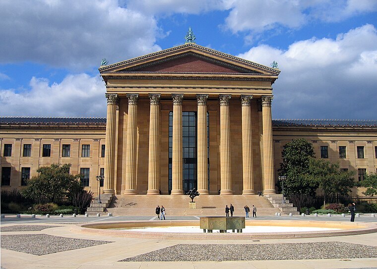
Photo: Wikimedia, Public domain.
The Philadelphia Art Museum, formerly the Philadelphia Museum of Art, is an art museum originally chartered in 1876 for the Centennial Exposition in Philadelphia. Philadelphia Art Museum is situated 2,700 feet south of Poplar Street & 25th Street.
Eastern State Penitentiary
Museum

Photo: Wikimedia, Public domain.
The Eastern State Penitentiary is a former American prison in Philadelphia, Pennsylvania. It is located in the Fairmount section of the city, and was operational from 1829 until 1971. Eastern State Penitentiary is situated 2,000 feet southeast of Poplar Street & 25th Street.
Hebron Memorial Church
Church

Photo: Wikimedia, Public domain.
Hebron Memorial Church is situated 1,100 feet north of Poplar Street & 25th Street.
Places in the Area
Nearby places include Fairmount and Brewerytown.
Fairmount
Neighborhood

Photo: goosegoddesss, CC BY-SA 2.0.
Fairmount is a neighborhood within Lower North Philadelphia, Pennsylvania, United States. Its boundaries are north of Fairmount Avenue, west of Corinthian Avenue, south of Girard Avenue and east of The Schuylkill River.
Brewerytown
Neighborhood

Photo: Smallbones, Public domain.
Brewerytown is a neighborhood in the North Philadelphia section of Philadelphia, Pennsylvania, United States. An unofficial region, Brewerytown runs approximately between the Schuylkill River's eastern bank and 25th Street, bounded by Montgomery Avenue to the north and Parrish Street to the south.
Sharswood
Neighborhood

Photo: Evrik, CC BY-SA 3.0.
Sharswood is a small neighborhood in the North Philadelphia section of the city of Philadelphia, Pennsylvania in the United States. It is located to the east of Brewerytown, north of Girard College, west of Ridge Avenue, east of 24th Street and south of Cecil B.
Poplar Street & 25th Street
- Type: Tram stop
- Also known as: “Poplar & 25th”
- Categories: railway stop, transport stop, and transportation
- Location: Philadelphia, Philadelphia, Philadelphia Region, Pennsylvania, Mid-Atlantic, United States, North America
- View on OpenStreetMap
Latitude
39.97246° or 39° 58′ 21″ northLongitude
-75.17742° or 75° 10′ 39″ westOpen location code
87F6XRCF+X2OpenStreetMap ID
node 6598207225OpenStreetMap feature
public_transport=stop_positionOpenStreetMap feature
railway=tram_stop
This page is based on OpenStreetMap, Wikidata, and Wikimedia Commons.
We’d love your help improving our open data sources. Thank you for contributing.
Satellite Map
Discover Poplar Street & 25th Street from above in high-definition satellite imagery.
Notable Places Nearby
Highlights include Saint Nicholas Church and Christian Hope Baptist Church.
Nearby Places
Explore places such as Constitution Hall and Christine Manley Hall.
Philadelphia: Must-Visit Destinations
Delve into Philadelphia International Airport, Old City, West Philadelphia, and Center City West.
Curious Tram Stops to Discover
Uncover intriguing tram stops from every corner of the globe.
About Mapcarta. Data © OpenStreetMap contributors and available under the Open Database License". Text is available under the CC BY-SA 4.0 license, except for photos, directions, and the map. Photo: Dave Z, CC BY 2.0.